You are here: Home > Network List > TA - USArray Transportable Network (new EarthScope stations) Stations List
> Station U50A Jamestown, TN, USA > Earthquake Result Viewer
U50A Jamestown, TN, USA - Earthquake Result Viewer

| Earthquake location: |
Crete, Greece |
| Earthquake latitude/longitude: |
34.3/25.2 |
| Earthquake time(UTC): |
2013/06/16 (167) 21:39:05 GMT |
| Earthquake Depth: |
19 km |
| Earthquake Magnitude: |
6.0 MW, 5.7 MS, 5.8 MW, 5.9 MB |
| Earthquake Catalog/Contributor: |
NEIC PDE/NEIC PDE-W |
|
| Network: |
TA USArray Transportable Network (new EarthScope stations) |
| Station: |
U50A Jamestown, TN, USA |
| Lat/Lon: |
36.42 N/84.84 W |
| Elevation: |
474 m |
|
| Distance: |
84.0 deg |
| Az: |
310.352 deg |
| Baz: |
51.416 deg |
| Ray Param: |
0.045738194 |
| Estimated Moho Depth: |
56.5 km |
| Estimated Crust Vp/Vs: |
1.65 |
| Assumed Crust Vp: |
6.476 km/s |
| Estimated Crust Vs: |
3.925 km/s |
| Estimated Crust Poisson's Ratio: |
0.21 |
|
| Radial Match: |
81.04593 % |
| Radial Bump: |
400 |
| Transverse Match: |
54.18226 % |
| Transverse Bump: |
400 |
| SOD ConfigId: |
512894 |
| Insert Time: |
2013-09-15 06:27:22.669 +0000 |
| GWidth: |
2.5 |
| Max Bumps: |
400 |
| Tol: |
0.001 |
|
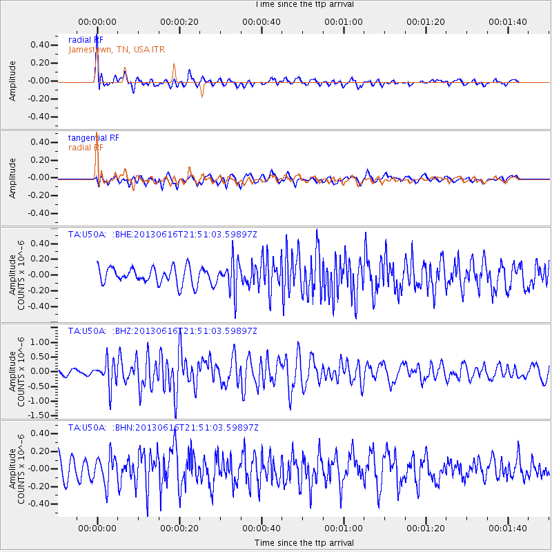
Signal To Noise
| Channel | StoN | STA | LTA |
| TA:U50A: :BHZ:20130616T21:51:03.59897Z | 5.1782546 | 4.3263532E-7 | 8.3548485E-8 |
| TA:U50A: :BHN:20130616T21:51:03.59897Z | 1.6573253 | 1.643415E-7 | 9.916067E-8 |
| TA:U50A: :BHE:20130616T21:51:03.59897Z | 1.8861274 | 1.967876E-7 | 1.043342E-7 |
| Arrivals |
| Ps | 5.8 SECOND |
| PpPs | 22 SECOND |
| PsPs/PpSs | 28 SECOND |


