You are here: Home > Network List > TA - USArray Transportable Network (new EarthScope stations) Stations List
> Station U51A La Follette, TN, USA > Earthquake Result Viewer
U51A La Follette, TN, USA - Earthquake Result Viewer
| Earthquake location: |
Crete, Greece |
| Earthquake latitude/longitude: |
34.3/25.2 |
| Earthquake time(UTC): |
2013/06/16 (167) 21:39:05 GMT |
| Earthquake Depth: |
19 km |
| Earthquake Magnitude: |
6.0 MW, 5.7 MS, 5.8 MW, 5.9 MB |
| Earthquake Catalog/Contributor: |
NEIC PDE/NEIC PDE-W |
|
| Network: |
TA USArray Transportable Network (new EarthScope stations) |
| Station: |
U51A La Follette, TN, USA |
| Lat/Lon: |
36.38 N/84.02 W |
| Elevation: |
472 m |
|
| Distance: |
83.5 deg |
| Az: |
309.907 deg |
| Baz: |
51.857 deg |
| Ray Param: |
0.04609248 |
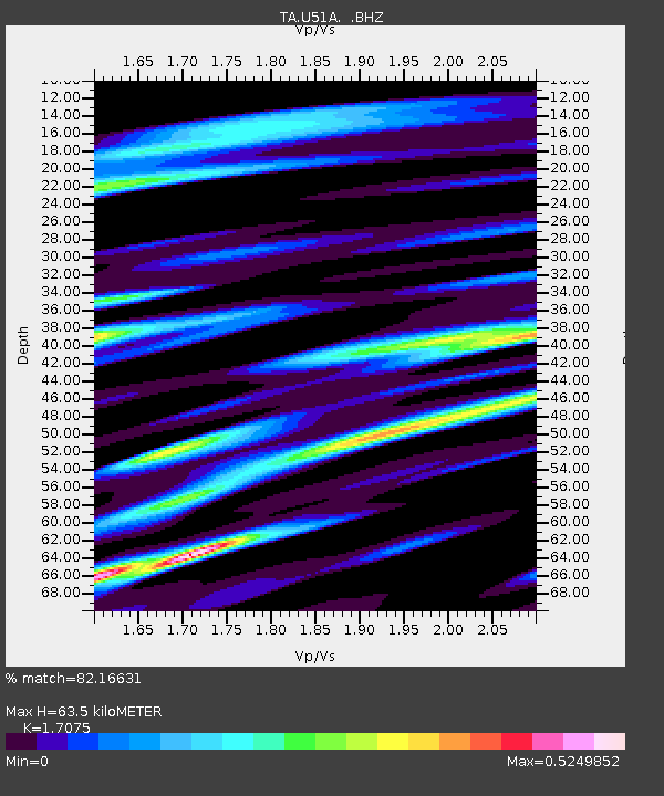
| Estimated Moho Depth: |
63.5 km |
| Estimated Crust Vp/Vs: |
1.71 |
| Assumed Crust Vp: |
6.476 km/s |
| Estimated Crust Vs: |
3.793 km/s |
| Estimated Crust Poisson's Ratio: |
0.24 |
|
| Radial Match: |
82.16631 % |
| Radial Bump: |
395 |
| Transverse Match: |
69.06661 % |
| Transverse Bump: |
400 |
| SOD ConfigId: |
512894 |
| Insert Time: |
2013-09-15 06:27:24.255 +0000 |
| GWidth: |
2.5 |
| Max Bumps: |
400 |
| Tol: |
0.001 |
|
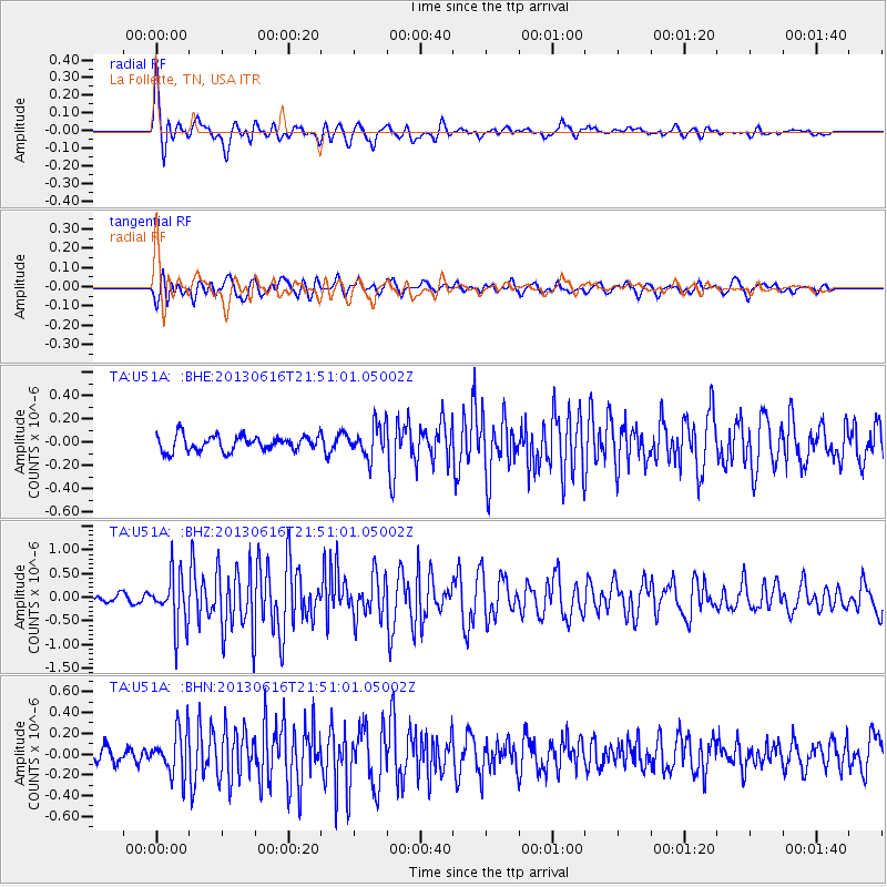
Signal To Noise
| Channel | StoN | STA | LTA |
| TA:U51A: :BHZ:20130616T21:51:01.05002Z | 8.755341 | 5.590112E-7 | 6.384803E-8 |
| TA:U51A: :BHN:20130616T21:51:01.05002Z | 2.399279 | 2.1451913E-7 | 8.940983E-8 |
| TA:U51A: :BHE:20130616T21:51:01.05002Z | 2.1012897 | 1.362419E-7 | 6.483727E-8 |
| Arrivals |
| Ps | 7.1 SECOND |
| PpPs | 26 SECOND |
| PsPs/PpSs | 33 SECOND |


