You are here: Home > Network List > TA - USArray Transportable Network (new EarthScope stations) Stations List
> Station W48A Pulaski, TN, USA > Earthquake Result Viewer
W48A Pulaski, TN, USA - Earthquake Result Viewer
| Earthquake location: |
Crete, Greece |
| Earthquake latitude/longitude: |
34.3/25.2 |
| Earthquake time(UTC): |
2013/06/16 (167) 21:39:05 GMT |
| Earthquake Depth: |
19 km |
| Earthquake Magnitude: |
6.0 MW, 5.7 MS, 5.8 MW, 5.9 MB |
| Earthquake Catalog/Contributor: |
NEIC PDE/NEIC PDE-W |
|
| Network: |
TA USArray Transportable Network (new EarthScope stations) |
| Station: |
W48A Pulaski, TN, USA |
| Lat/Lon: |
35.14 N/86.93 W |
| Elevation: |
260 m |
|
| Distance: |
86.2 deg |
| Az: |
310.439 deg |
| Baz: |
50.207 deg |
| Ray Param: |
0.044225145 |
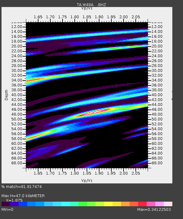
| Estimated Moho Depth: |
47.0 km |
| Estimated Crust Vp/Vs: |
1.88 |
| Assumed Crust Vp: |
6.476 km/s |
| Estimated Crust Vs: |
3.454 km/s |
| Estimated Crust Poisson's Ratio: |
0.30 |
|
| Radial Match: |
81.817474 % |
| Radial Bump: |
386 |
| Transverse Match: |
68.79964 % |
| Transverse Bump: |
400 |
| SOD ConfigId: |
512894 |
| Insert Time: |
2013-09-15 06:28:47.538 +0000 |
| GWidth: |
2.5 |
| Max Bumps: |
400 |
| Tol: |
0.001 |
|

Signal To Noise
| Channel | StoN | STA | LTA |
| TA:W48A: :BHZ:20130616T21:51:14.199983Z | 8.752091 | 6.599231E-7 | 7.540176E-8 |
| TA:W48A: :BHN:20130616T21:51:14.199983Z | 2.7281418 | 1.6602957E-7 | 6.085812E-8 |
| TA:W48A: :BHE:20130616T21:51:14.199983Z | 2.198908 | 1.1231449E-7 | 5.1077393E-8 |
| Arrivals |
| Ps | 6.5 SECOND |
| PpPs | 20 SECOND |
| PsPs/PpSs | 27 SECOND |


