You are here: Home > Network List > TA - USArray Transportable Network (new EarthScope stations) Stations List
> Station Z41A Richland Creek Farm, El Dorado, AR, USA > Earthquake Result Viewer
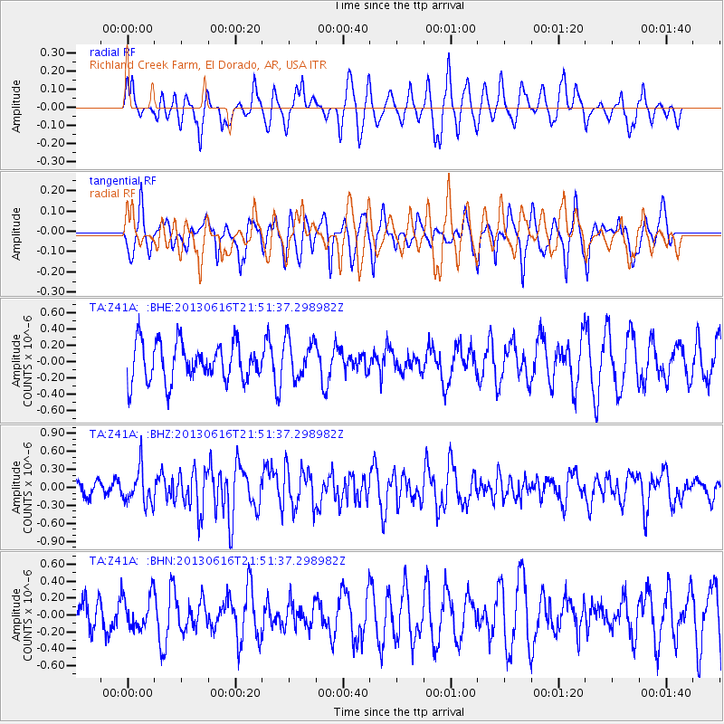
Z41A Richland Creek Farm, El Dorado, AR, USA - Earthquake Result Viewer
*The percent match for this event was below the threshold and hence no stack was calculated.
| Earthquake location: |
Crete, Greece |
| Earthquake latitude/longitude: |
34.3/25.2 |
| Earthquake time(UTC): |
2013/06/16 (167) 21:39:05 GMT |
| Earthquake Depth: |
19 km |
| Earthquake Magnitude: |
6.0 MW, 5.7 MS, 5.8 MW, 5.9 MB |
| Earthquake Catalog/Contributor: |
NEIC PDE/NEIC PDE-W |
|
| Network: |
TA USArray Transportable Network (new EarthScope stations) |
| Station: |
Z41A Richland Creek Farm, El Dorado, AR, USA |
| Lat/Lon: |
33.26 N/92.80 W |
| Elevation: |
62 m |
|
| Distance: |
91.1 deg |
| Az: |
312.251 deg |
| Baz: |
46.964 deg |
| Ray Param: |
$rayparam |
*The percent match for this event was below the threshold and hence was not used in the summary stack. |
|
| Radial Match: |
49.541664 % |
| Radial Bump: |
400 |
| Transverse Match: |
61.616745 % |
| Transverse Bump: |
386 |
| SOD ConfigId: |
512894 |
| Insert Time: |
2013-09-15 06:30:31.891 +0000 |
| GWidth: |
2.5 |
| Max Bumps: |
400 |
| Tol: |
0.001 |
|
Signal To Noise
| Channel | StoN | STA | LTA |
| TA:Z41A: :BHZ:20130616T21:51:37.298982Z | 2.6718462 | 2.998407E-7 | 1.12222295E-7 |
| TA:Z41A: :BHN:20130616T21:51:37.298982Z | 1.05437 | 1.9381021E-7 | 1.8381611E-7 |
| TA:Z41A: :BHE:20130616T21:51:37.298982Z | 1.0192996 | 2.4128641E-7 | 2.3671785E-7 |
| Arrivals |
| Ps | |
| PpPs | |
| PsPs/PpSs | |


