You are here: Home > Network List > US - United States National Seismic Network Stations List
> Station MSO Missoula, Montana, USA > Earthquake Result Viewer
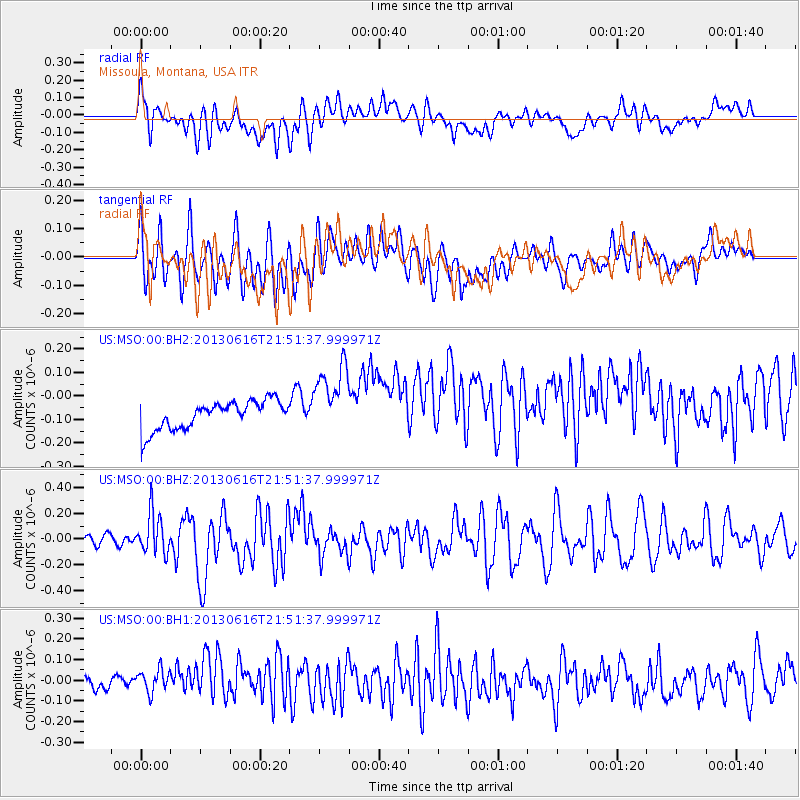
MSO Missoula, Montana, USA - Earthquake Result Viewer
*The percent match for this event was below the threshold and hence no stack was calculated.
| Earthquake location: |
Crete, Greece |
| Earthquake latitude/longitude: |
34.3/25.2 |
| Earthquake time(UTC): |
2013/06/16 (167) 21:39:05 GMT |
| Earthquake Depth: |
19 km |
| Earthquake Magnitude: |
6.0 MW, 5.7 MS, 5.8 MW, 5.9 MB |
| Earthquake Catalog/Contributor: |
NEIC PDE/NEIC PDE-W |
|
| Network: |
US United States National Seismic Network |
| Station: |
MSO Missoula, Montana, USA |
| Lat/Lon: |
46.83 N/113.94 W |
| Elevation: |
1264 m |
|
| Distance: |
91.2 deg |
| Az: |
333.278 deg |
| Baz: |
32.81 deg |
| Ray Param: |
$rayparam |
*The percent match for this event was below the threshold and hence was not used in the summary stack. |
|
| Radial Match: |
47.395058 % |
| Radial Bump: |
400 |
| Transverse Match: |
59.80271 % |
| Transverse Bump: |
400 |
| SOD ConfigId: |
512894 |
| Insert Time: |
2013-09-15 06:32:59.894 +0000 |
| GWidth: |
2.5 |
| Max Bumps: |
400 |
| Tol: |
0.001 |
|
Signal To Noise
| Channel | StoN | STA | LTA |
| US:MSO:00:BHZ:20130616T21:51:37.999971Z | 2.5982811 | 1.5669262E-7 | 6.030626E-8 |
| US:MSO:00:BH1:20130616T21:51:37.999971Z | 1.5524248 | 6.854281E-8 | 4.4152095E-8 |
| US:MSO:00:BH2:20130616T21:51:37.999971Z | 2.5688143 | 1.5470107E-7 | 6.022276E-8 |
| Arrivals |
| Ps | |
| PpPs | |
| PsPs/PpSs | |


