You are here: Home > Network List > TA - USArray Transportable Network (new EarthScope stations) Stations List
> Station G05D Wamic, OR, USA > Earthquake Result Viewer
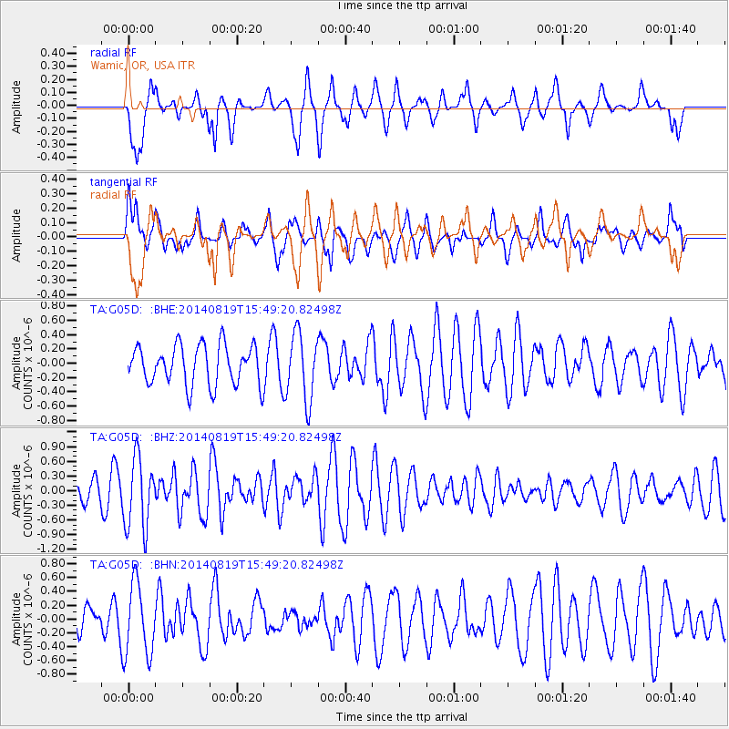
G05D Wamic, OR, USA - Earthquake Result Viewer
*The percent match for this event was below the threshold and hence no stack was calculated.
| Earthquake location: |
South Of Fiji Islands |
| Earthquake latitude/longitude: |
-22.1/-179.5 |
| Earthquake time(UTC): |
2014/08/19 (231) 15:38:17 GMT |
| Earthquake Depth: |
602 km |
| Earthquake Magnitude: |
5.4 MW, 5.2 mb |
| Earthquake Catalog/Contributor: |
ISC/ISC |
|
| Network: |
TA USArray Transportable Network (new EarthScope stations) |
| Station: |
G05D Wamic, OR, USA |
| Lat/Lon: |
45.24 N/121.32 W |
| Elevation: |
592 m |
|
| Distance: |
85.3 deg |
| Az: |
37.021 deg |
| Baz: |
232.236 deg |
| Ray Param: |
$rayparam |
*The percent match for this event was below the threshold and hence was not used in the summary stack. |
|
| Radial Match: |
64.69721 % |
| Radial Bump: |
400 |
| Transverse Match: |
47.369705 % |
| Transverse Bump: |
400 |
| SOD ConfigId: |
3390531 |
| Insert Time: |
2019-04-13 11:29:32.500 +0000 |
| GWidth: |
2.5 |
| Max Bumps: |
400 |
| Tol: |
0.001 |
|
Signal To Noise
| Channel | StoN | STA | LTA |
| TA:G05D: :BHZ:20140819T15:49:20.82498Z | 2.6197722 | 7.285252E-7 | 2.7808724E-7 |
| TA:G05D: :BHN:20140819T15:49:20.82498Z | 1.1968164 | 5.237588E-7 | 4.3762668E-7 |
| TA:G05D: :BHE:20140819T15:49:20.82498Z | 1.6870719 | 4.6912137E-7 | 2.780684E-7 |
| Arrivals |
| Ps | |
| PpPs | |
| PsPs/PpSs | |


