You are here: Home > Network List > TA - USArray Transportable Network (new EarthScope stations) Stations List
> Station M44A Midewin, Midewin Nat. Tallgrass Prarie, IL, USA > Earthquake Result Viewer
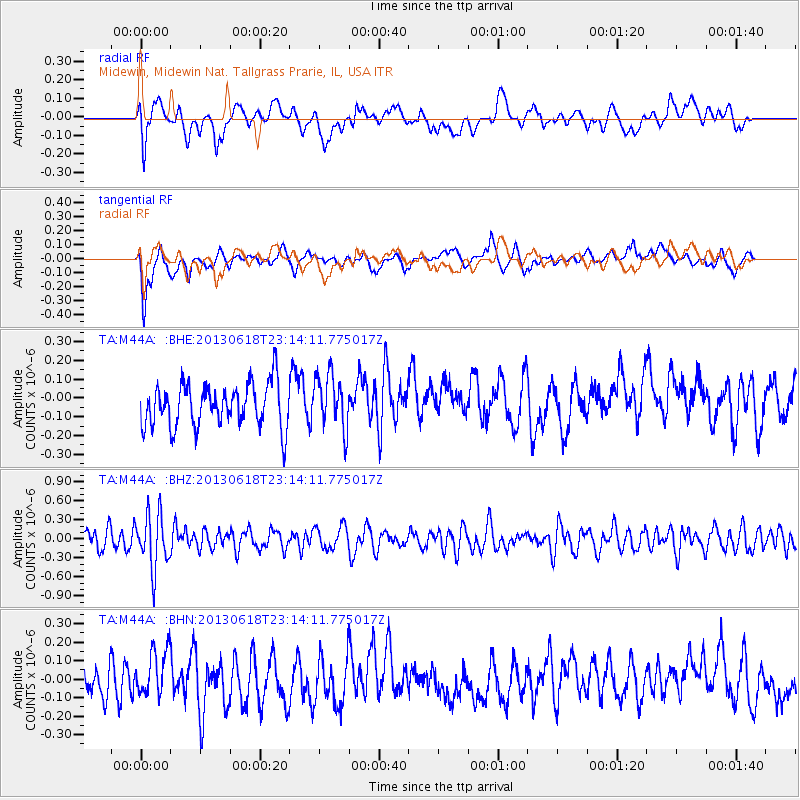
M44A Midewin, Midewin Nat. Tallgrass Prarie, IL, USA - Earthquake Result Viewer
*The percent match for this event was below the threshold and hence no stack was calculated.
| Earthquake location: |
Southwestern Siberia, Russia |
| Earthquake latitude/longitude: |
54.3/86.2 |
| Earthquake time(UTC): |
2013/06/18 (169) 23:02:09 GMT |
| Earthquake Depth: |
9.9 km |
| Earthquake Magnitude: |
5.6 MB |
| Earthquake Catalog/Contributor: |
NEIC PDE/NEIC PDE-W |
|
| Network: |
TA USArray Transportable Network (new EarthScope stations) |
| Station: |
M44A Midewin, Midewin Nat. Tallgrass Prarie, IL, USA |
| Lat/Lon: |
41.39 N/88.04 W |
| Elevation: |
207 m |
|
| Distance: |
84.6 deg |
| Az: |
355.632 deg |
| Baz: |
3.404 deg |
| Ray Param: |
$rayparam |
*The percent match for this event was below the threshold and hence was not used in the summary stack. |
|
| Radial Match: |
57.42337 % |
| Radial Bump: |
400 |
| Transverse Match: |
61.353573 % |
| Transverse Bump: |
400 |
| SOD ConfigId: |
512894 |
| Insert Time: |
2013-09-15 07:19:38.067 +0000 |
| GWidth: |
2.5 |
| Max Bumps: |
400 |
| Tol: |
0.001 |
|
Signal To Noise
| Channel | StoN | STA | LTA |
| TA:M44A: :BHZ:20130618T23:14:11.775017Z | 2.7641616 | 4.2886103E-7 | 1.5515049E-7 |
| TA:M44A: :BHN:20130618T23:14:11.775017Z | 1.2404785 | 1.2192926E-7 | 9.829211E-8 |
| TA:M44A: :BHE:20130618T23:14:11.775017Z | 1.2835532 | 1.4695496E-7 | 1.1449074E-7 |
| Arrivals |
| Ps | |
| PpPs | |
| PsPs/PpSs | |


