You are here: Home > Network List > TA - USArray Transportable Network (new EarthScope stations) Stations List
> Station V60A Jim Taylor Road, Stokes, NC, USA > Earthquake Result Viewer
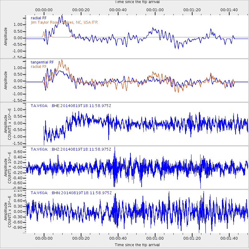
V60A Jim Taylor Road, Stokes, NC, USA - Earthquake Result Viewer
*The percent match for this event was below the threshold and hence no stack was calculated.
| Earthquake location: |
Iran-Iraq Border Region |
| Earthquake latitude/longitude: |
32.6/47.6 |
| Earthquake time(UTC): |
2014/08/19 (231) 17:59:10 GMT |
| Earthquake Depth: |
13 km |
| Earthquake Magnitude: |
4.5 mb, 4.7 mb |
| Earthquake Catalog/Contributor: |
ISC/ISC |
|
| Network: |
TA USArray Transportable Network (new EarthScope stations) |
| Station: |
V60A Jim Taylor Road, Stokes, NC, USA |
| Lat/Lon: |
35.76 N/77.26 W |
| Elevation: |
8.0 m |
|
| Distance: |
94.6 deg |
| Az: |
317.998 deg |
| Baz: |
43.996 deg |
| Ray Param: |
$rayparam |
*The percent match for this event was below the threshold and hence was not used in the summary stack. |
|
| Radial Match: |
31.418852 % |
| Radial Bump: |
400 |
| Transverse Match: |
37.405945 % |
| Transverse Bump: |
400 |
| SOD ConfigId: |
3390531 |
| Insert Time: |
2019-04-13 11:36:10.242 +0000 |
| GWidth: |
2.5 |
| Max Bumps: |
400 |
| Tol: |
0.001 |
|
Signal To Noise
| Channel | StoN | STA | LTA |
| TA:V60A: :BHZ:20140819T18:11:58.975Z | 0.8439808 | 1.3806981E-7 | 1.6359354E-7 |
| TA:V60A: :BHN:20140819T18:11:58.975Z | 0.7692388 | 3.011101E-7 | 3.9143902E-7 |
| TA:V60A: :BHE:20140819T18:11:58.975Z | 0.84677833 | 4.884581E-7 | 5.76843E-7 |
| Arrivals |
| Ps | |
| PpPs | |
| PsPs/PpSs | |


