You are here: Home > Network List > TA - USArray Transportable Network (new EarthScope stations) Stations List
> Station X46A Booneville, MS, USA > Earthquake Result Viewer
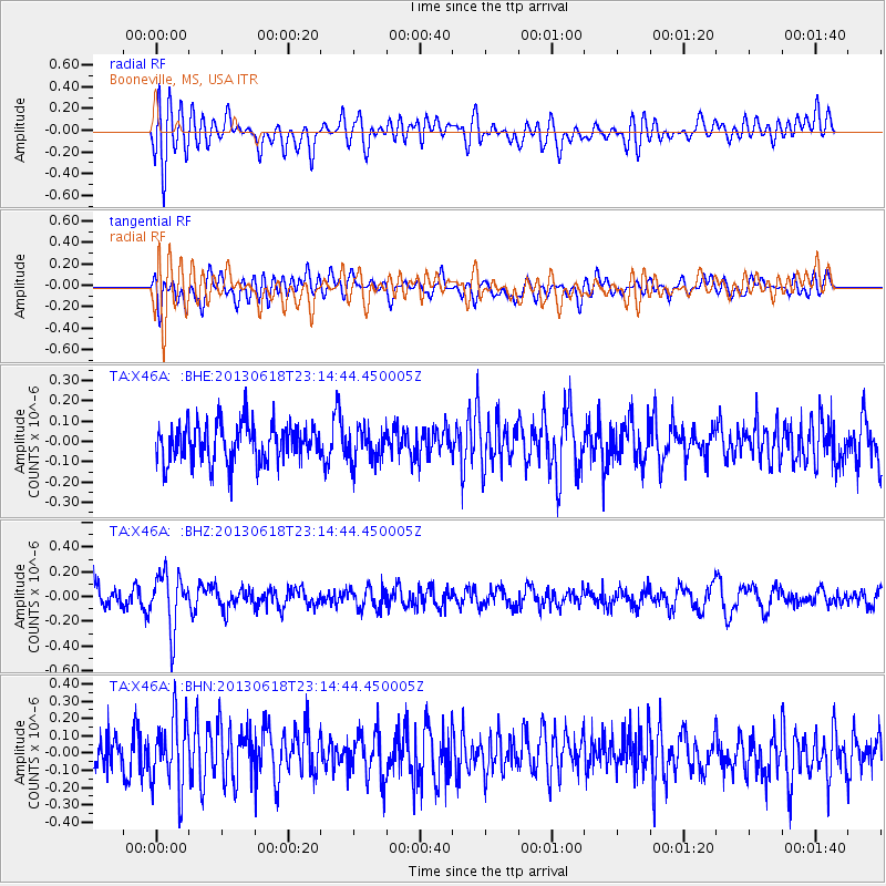
X46A Booneville, MS, USA - Earthquake Result Viewer
*The percent match for this event was below the threshold and hence no stack was calculated.
| Earthquake location: |
Southwestern Siberia, Russia |
| Earthquake latitude/longitude: |
54.3/86.2 |
| Earthquake time(UTC): |
2013/06/18 (169) 23:02:09 GMT |
| Earthquake Depth: |
9.9 km |
| Earthquake Magnitude: |
5.6 MB |
| Earthquake Catalog/Contributor: |
NEIC PDE/NEIC PDE-W |
|
| Network: |
TA USArray Transportable Network (new EarthScope stations) |
| Station: |
X46A Booneville, MS, USA |
| Lat/Lon: |
34.56 N/88.58 W |
| Elevation: |
150 m |
|
| Distance: |
91.4 deg |
| Az: |
355.674 deg |
| Baz: |
3.074 deg |
| Ray Param: |
$rayparam |
*The percent match for this event was below the threshold and hence was not used in the summary stack. |
|
| Radial Match: |
52.147182 % |
| Radial Bump: |
400 |
| Transverse Match: |
55.640675 % |
| Transverse Bump: |
400 |
| SOD ConfigId: |
512894 |
| Insert Time: |
2013-09-15 07:29:34.441 +0000 |
| GWidth: |
2.5 |
| Max Bumps: |
400 |
| Tol: |
0.001 |
|
Signal To Noise
| Channel | StoN | STA | LTA |
| TA:X46A: :BHZ:20130618T23:14:44.450005Z | 2.5409033 | 2.2163336E-7 | 8.7226205E-8 |
| TA:X46A: :BHN:20130618T23:14:44.450005Z | 1.6762199 | 1.9344822E-7 | 1.1540742E-7 |
| TA:X46A: :BHE:20130618T23:14:44.450005Z | 0.8709842 | 8.2557655E-8 | 9.478662E-8 |
| Arrivals |
| Ps | |
| PpPs | |
| PsPs/PpSs | |


