LCCR Mulino, OR, USA - Earthquake Result Viewer
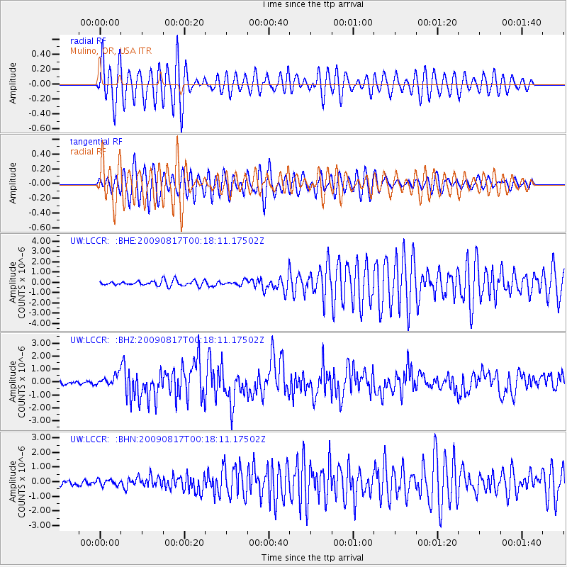
Earthquake location: Southwestern Ryukyu Isl., Japan
Earthquake latitude/longitude: 23.5/123.5
Earthquake time(UTC): 2009/08/17 (229) 00:05:49 GMT
Earthquake Depth: 20 km
Earthquake Magnitude: 6.2 MB, 6.6 MS, 6.7 MW, 6.6 MW
Earthquake Catalog/Contributor: WHDF/NEIC
Network: UW Pacific Northwest Regional Seismic Network
Station: LCCR Mulino, OR, USA
Lat/Lon: 45.21 N/122.48 W
Elevation: 273 m
Distance: 89.1 deg
Az: 40.225 deg
Baz: 303.005 deg
Ray Param: 0.042102296
Estimated Moho Depth: 32.0 km
Estimated Crust Vp/Vs: 2.01
Assumed Crust Vp: 6.566 km/s
Estimated Crust Vs: 3.267 km/s
Estimated Crust Poisson's Ratio: 0.34
Radial Match: 86.91012 %
Radial Bump: 400
Transverse Match: 86.87089 %
Transverse Bump: 400
SOD ConfigId: 2622
Insert Time: 2010-02-27 04:36:45.374 +0000
GWidth: 2.5
Max Bumps: 400
Tol: 0.001

Signal To Noise

ChannelStoNSTALTA
UW:LCCR: :BHZ:20090817T00:18:11.17502Z2.89319044.3753428E-71.5122899E-7
UW:LCCR: :BHN:20090817T00:18:11.17502Z0.97851011.968716E-72.0119526E-7
UW:LCCR: :BHE:20090817T00:18:11.17502Z0.84885822.0992871E-72.4730718E-7
Arrivals
Ps5.0 SECOND
PpPs14 SECOND
PsPs/PpSs19 SECOND