You are here: Home > Network List > TA - USArray Transportable Network (new EarthScope stations) Stations List
> Station P56A Dayton Farm, Ripley, WV, USA > Earthquake Result Viewer
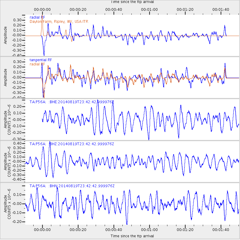
P56A Dayton Farm, Ripley, WV, USA - Earthquake Result Viewer
*The percent match for this event was below the threshold and hence no stack was calculated.
| Earthquake location: |
Iran-Iraq Border Region |
| Earthquake latitude/longitude: |
32.6/47.5 |
| Earthquake time(UTC): |
2014/08/19 (231) 23:30:04 GMT |
| Earthquake Depth: |
26 km |
| Earthquake Magnitude: |
4.6 mb |
| Earthquake Catalog/Contributor: |
ISC/ISC |
|
| Network: |
TA USArray Transportable Network (new EarthScope stations) |
| Station: |
P56A Dayton Farm, Ripley, WV, USA |
| Lat/Lon: |
39.50 N/78.84 W |
| Elevation: |
249 m |
|
| Distance: |
92.7 deg |
| Az: |
321.411 deg |
| Baz: |
42.861 deg |
| Ray Param: |
$rayparam |
*The percent match for this event was below the threshold and hence was not used in the summary stack. |
|
| Radial Match: |
55.24635 % |
| Radial Bump: |
400 |
| Transverse Match: |
54.90656 % |
| Transverse Bump: |
400 |
| SOD ConfigId: |
3390531 |
| Insert Time: |
2019-04-13 11:41:50.781 +0000 |
| GWidth: |
2.5 |
| Max Bumps: |
400 |
| Tol: |
0.001 |
|
Signal To Noise
| Channel | StoN | STA | LTA |
| TA:P56A: :BHZ:20140819T23:42:42.999976Z | 3.144608 | 2.5268938E-7 | 8.035639E-8 |
| TA:P56A: :BHN:20140819T23:42:42.999976Z | 0.8693041 | 4.600154E-8 | 5.291766E-8 |
| TA:P56A: :BHE:20140819T23:42:42.999976Z | 2.4001496 | 1.8510312E-7 | 7.71215E-8 |
| Arrivals |
| Ps | |
| PpPs | |
| PsPs/PpSs | |


