You are here: Home > Network List > TA - USArray Transportable Network (new EarthScope stations) Stations List
> Station W57A Gilead, NC, USA > Earthquake Result Viewer
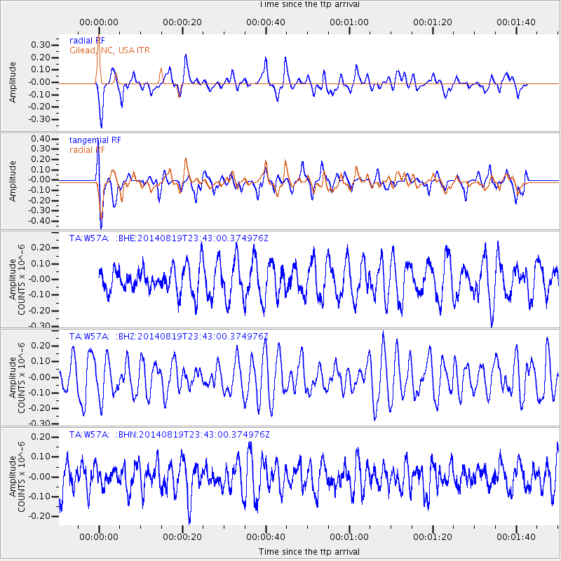
W57A Gilead, NC, USA - Earthquake Result Viewer
*The percent match for this event was below the threshold and hence no stack was calculated.
| Earthquake location: |
Iran-Iraq Border Region |
| Earthquake latitude/longitude: |
32.6/47.5 |
| Earthquake time(UTC): |
2014/08/19 (231) 23:30:04 GMT |
| Earthquake Depth: |
26 km |
| Earthquake Magnitude: |
4.6 mb |
| Earthquake Catalog/Contributor: |
ISC/ISC |
|
| Network: |
TA USArray Transportable Network (new EarthScope stations) |
| Station: |
W57A Gilead, NC, USA |
| Lat/Lon: |
35.15 N/79.99 W |
| Elevation: |
85 m |
|
| Distance: |
96.5 deg |
| Az: |
319.142 deg |
| Baz: |
42.345 deg |
| Ray Param: |
$rayparam |
*The percent match for this event was below the threshold and hence was not used in the summary stack. |
|
| Radial Match: |
61.97342 % |
| Radial Bump: |
400 |
| Transverse Match: |
75.52762 % |
| Transverse Bump: |
400 |
| SOD ConfigId: |
3390531 |
| Insert Time: |
2019-04-13 11:42:02.286 +0000 |
| GWidth: |
2.5 |
| Max Bumps: |
400 |
| Tol: |
0.001 |
|
Signal To Noise
| Channel | StoN | STA | LTA |
| TA:W57A: :BHZ:20140819T23:43:00.374976Z | 1.2022451 | 1.1842035E-7 | 9.849934E-8 |
| TA:W57A: :BHN:20140819T23:43:00.374976Z | 0.5019132 | 4.460033E-8 | 8.8860645E-8 |
| TA:W57A: :BHE:20140819T23:43:00.374976Z | 1.641718 | 1.255178E-7 | 7.645516E-8 |
| Arrivals |
| Ps | |
| PpPs | |
| PsPs/PpSs | |


