You are here: Home > Network List > UW - Pacific Northwest Regional Seismic Network Stations List
> Station LCCR Mulino, OR, USA > Earthquake Result Viewer
LCCR Mulino, OR, USA - Earthquake Result Viewer
| Earthquake location: |
Honduras |
| Earthquake latitude/longitude: |
15.8/-86.9 |
| Earthquake time(UTC): |
2009/06/08 (159) 05:13:14 GMT |
| Earthquake Depth: |
10 km |
| Earthquake Magnitude: |
5.5 MB, 4.9 MS, 5.4 MW, 5.4 MW |
| Earthquake Catalog/Contributor: |
WHDF/NEIC |
|
| Network: |
UW Pacific Northwest Regional Seismic Network |
| Station: |
LCCR Mulino, OR, USA |
| Lat/Lon: |
45.21 N/122.48 W |
| Elevation: |
273 m |
|
| Distance: |
41.9 deg |
| Az: |
321.925 deg |
| Baz: |
122.877 deg |
| Ray Param: |
0.073513575 |
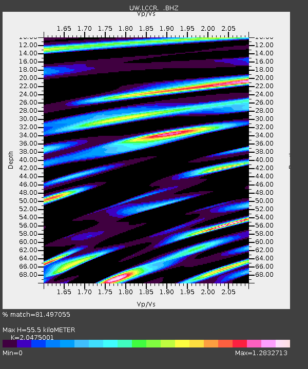
| Estimated Moho Depth: |
55.5 km |
| Estimated Crust Vp/Vs: |
2.05 |
| Assumed Crust Vp: |
6.566 km/s |
| Estimated Crust Vs: |
3.207 km/s |
| Estimated Crust Poisson's Ratio: |
0.34 |
|
| Radial Match: |
81.497055 % |
| Radial Bump: |
400 |
| Transverse Match: |
78.71663 % |
| Transverse Bump: |
400 |
| SOD ConfigId: |
2648 |
| Insert Time: |
2010-02-27 04:36:59.379 +0000 |
| GWidth: |
2.5 |
| Max Bumps: |
400 |
| Tol: |
0.001 |
|

Signal To Noise
| Channel | StoN | STA | LTA |
| UW:LCCR: :BHZ:20090608T05:20:34.074012Z | 15.290494 | 1.2198307E-6 | 7.977706E-8 |
| UW:LCCR: :BHN:20090608T05:20:34.074012Z | 3.203377 | 6.304103E-7 | 1.9679554E-7 |
| UW:LCCR: :BHE:20090608T05:20:34.074012Z | 2.6417713 | 5.6622025E-7 | 2.1433357E-7 |
| Arrivals |
| Ps | 9.4 SECOND |
| PpPs | 24 SECOND |
| PsPs/PpSs | 34 SECOND |


