You are here: Home > Network List > UW - Pacific Northwest Regional Seismic Network Stations List
> Station LCCR Mulino, OR, USA > Earthquake Result Viewer
LCCR Mulino, OR, USA - Earthquake Result Viewer
| Earthquake location: |
Taiwan Region |
| Earthquake latitude/longitude: |
24.1/122.2 |
| Earthquake time(UTC): |
2009/07/13 (194) 18:05:01 GMT |
| Earthquake Depth: |
17 km |
| Earthquake Magnitude: |
6.1 MB, 6.3 MS, 6.3 MW, 6.2 MW |
| Earthquake Catalog/Contributor: |
WHDF/NEIC |
|
| Network: |
UW Pacific Northwest Regional Seismic Network |
| Station: |
LCCR Mulino, OR, USA |
| Lat/Lon: |
45.21 N/122.48 W |
| Elevation: |
273 m |
|
| Distance: |
89.4 deg |
| Az: |
39.722 deg |
| Baz: |
304.271 deg |
| Ray Param: |
0.041859064 |
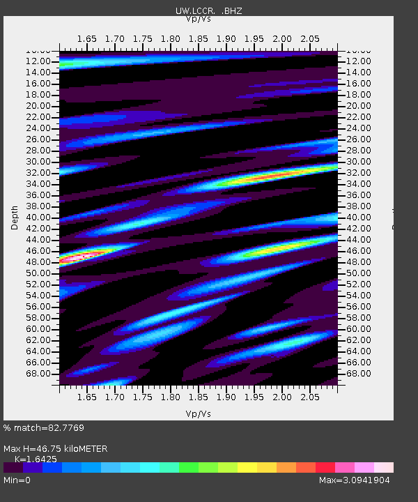
| Estimated Moho Depth: |
46.75 km |
| Estimated Crust Vp/Vs: |
1.64 |
| Assumed Crust Vp: |
6.566 km/s |
| Estimated Crust Vs: |
3.998 km/s |
| Estimated Crust Poisson's Ratio: |
0.21 |
|
| Radial Match: |
82.7769 % |
| Radial Bump: |
400 |
| Transverse Match: |
84.26637 % |
| Transverse Bump: |
400 |
| SOD ConfigId: |
2648 |
| Insert Time: |
2010-02-27 04:37:06.438 +0000 |
| GWidth: |
2.5 |
| Max Bumps: |
400 |
| Tol: |
0.001 |
|
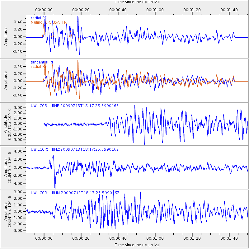
Signal To Noise
| Channel | StoN | STA | LTA |
| UW:LCCR: :BHZ:20090713T18:17:25.599016Z | 10.881143 | 9.978182E-7 | 9.17016E-8 |
| UW:LCCR: :BHN:20090713T18:17:25.599016Z | 0.9819761 | 1.4710886E-7 | 1.49809E-7 |
| UW:LCCR: :BHE:20090713T18:17:25.599016Z | 1.9850692 | 2.1748318E-7 | 1.09559494E-7 |
| Arrivals |
| Ps | 4.7 SECOND |
| PpPs | 18 SECOND |
| PsPs/PpSs | 23 SECOND |


