You are here: Home > Network List > UW - Pacific Northwest Regional Seismic Network Stations List
> Station LCCR Mulino, OR, USA > Earthquake Result Viewer
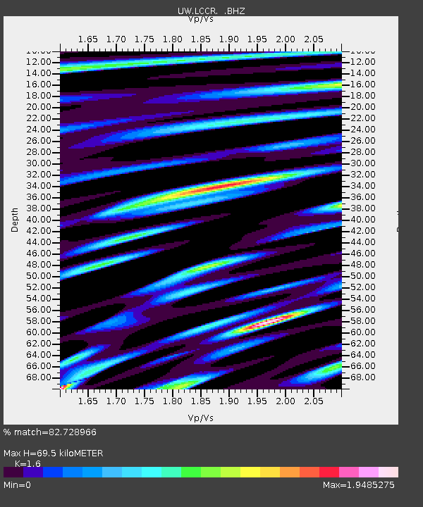
LCCR Mulino, OR, USA - Earthquake Result Viewer
| Earthquake location: |
Guatemala |
| Earthquake latitude/longitude: |
14.6/-91.2 |
| Earthquake time(UTC): |
2009/05/03 (123) 16:21:47 GMT |
| Earthquake Depth: |
124 km |
| Earthquake Magnitude: |
5.6 MB, 6.2 MW, 6.2 MW |
| Earthquake Catalog/Contributor: |
WHDF/NEIC |
|
| Network: |
UW Pacific Northwest Regional Seismic Network |
| Station: |
LCCR Mulino, OR, USA |
| Lat/Lon: |
45.21 N/122.48 W |
| Elevation: |
273 m |
|
| Distance: |
40.4 deg |
| Az: |
325.465 deg |
| Baz: |
129.062 deg |
| Ray Param: |
0.073991016 |
| Estimated Moho Depth: |
69.5 km |
| Estimated Crust Vp/Vs: |
1.60 |
| Assumed Crust Vp: |
6.566 km/s |
| Estimated Crust Vs: |
4.104 km/s |
| Estimated Crust Poisson's Ratio: |
0.18 |
|
| Radial Match: |
82.728966 % |
| Radial Bump: |
400 |
| Transverse Match: |
81.2897 % |
| Transverse Bump: |
400 |
| SOD ConfigId: |
2658 |
| Insert Time: |
2010-02-27 04:37:08.784 +0000 |
| GWidth: |
2.5 |
| Max Bumps: |
400 |
| Tol: |
0.001 |
|

Signal To Noise
| Channel | StoN | STA | LTA |
| UW:LCCR: :BHZ:20090503T16:28:42.450012Z | 14.166078 | 2.4322758E-6 | 1.716972E-7 |
| UW:LCCR: :BHN:20090503T16:28:42.450012Z | 2.6870441 | 1.1510783E-6 | 4.283809E-7 |
| UW:LCCR: :BHE:20090503T16:28:42.450012Z | 3.7605352 | 1.0797716E-6 | 2.871324E-7 |
| Arrivals |
| Ps | 6.9 SECOND |
| PpPs | 25 SECOND |
| PsPs/PpSs | 32 SECOND |


