You are here: Home > Network List > TA - USArray Transportable Network (new EarthScope stations) Stations List
> Station N49A Columbus Grove, OH, USA > Earthquake Result Viewer
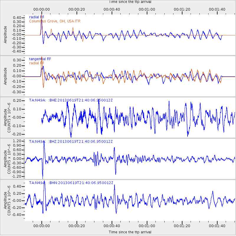
N49A Columbus Grove, OH, USA - Earthquake Result Viewer
*The percent match for this event was below the threshold and hence no stack was calculated.
| Earthquake location: |
Chile-Argentina Border Region |
| Earthquake latitude/longitude: |
-32.7/-70.0 |
| Earthquake time(UTC): |
2013/06/19 (170) 21:29:11 GMT |
| Earthquake Depth: |
104 km |
| Earthquake Magnitude: |
5.5 MB |
| Earthquake Catalog/Contributor: |
NEIC PDE/NEIC PDE-W |
|
| Network: |
TA USArray Transportable Network (new EarthScope stations) |
| Station: |
N49A Columbus Grove, OH, USA |
| Lat/Lon: |
40.92 N/84.18 W |
| Elevation: |
225 m |
|
| Distance: |
74.4 deg |
| Az: |
348.915 deg |
| Baz: |
167.641 deg |
| Ray Param: |
$rayparam |
*The percent match for this event was below the threshold and hence was not used in the summary stack. |
|
| Radial Match: |
66.589615 % |
| Radial Bump: |
400 |
| Transverse Match: |
61.25609 % |
| Transverse Bump: |
400 |
| SOD ConfigId: |
512894 |
| Insert Time: |
2013-09-15 08:21:43.965 +0000 |
| GWidth: |
2.5 |
| Max Bumps: |
400 |
| Tol: |
0.001 |
|
Signal To Noise
| Channel | StoN | STA | LTA |
| TA:N49A: :BHZ:20130619T21:40:06.950012Z | 4.391155 | 4.518761E-7 | 1.0290598E-7 |
| TA:N49A: :BHN:20130619T21:40:06.950012Z | 2.79535 | 2.2815306E-7 | 8.161878E-8 |
| TA:N49A: :BHE:20130619T21:40:06.950012Z | 1.4497606 | 1.0315891E-7 | 7.1155824E-8 |
| Arrivals |
| Ps | |
| PpPs | |
| PsPs/PpSs | |


