You are here: Home > Network List > TA - USArray Transportable Network (new EarthScope stations) Stations List
> Station O03E Paynes Creek, CA, USA > Earthquake Result Viewer
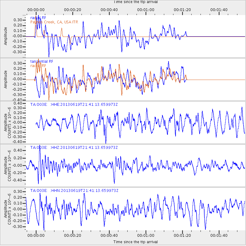
O03E Paynes Creek, CA, USA - Earthquake Result Viewer
*The percent match for this event was below the threshold and hence no stack was calculated.
| Earthquake location: |
Chile-Argentina Border Region |
| Earthquake latitude/longitude: |
-32.7/-70.0 |
| Earthquake time(UTC): |
2013/06/19 (170) 21:29:11 GMT |
| Earthquake Depth: |
104 km |
| Earthquake Magnitude: |
5.5 MB |
| Earthquake Catalog/Contributor: |
NEIC PDE/NEIC PDE-W |
|
| Network: |
TA USArray Transportable Network (new EarthScope stations) |
| Station: |
O03E Paynes Creek, CA, USA |
| Lat/Lon: |
40.29 N/121.80 W |
| Elevation: |
967 m |
|
| Distance: |
86.9 deg |
| Az: |
323.013 deg |
| Baz: |
138.431 deg |
| Ray Param: |
$rayparam |
*The percent match for this event was below the threshold and hence was not used in the summary stack. |
|
| Radial Match: |
55.23806 % |
| Radial Bump: |
400 |
| Transverse Match: |
58.08039 % |
| Transverse Bump: |
400 |
| SOD ConfigId: |
512894 |
| Insert Time: |
2013-09-15 08:22:09.377 +0000 |
| GWidth: |
2.5 |
| Max Bumps: |
400 |
| Tol: |
0.001 |
|
Signal To Noise
| Channel | StoN | STA | LTA |
| TA:O03E: :HHZ:20130619T21:41:13.659973Z | 3.0742736 | 2.308043E-7 | 7.5076045E-8 |
| TA:O03E: :HHN:20130619T21:41:13.659973Z | 2.1980937 | 1.8431086E-7 | 8.3850324E-8 |
| TA:O03E: :HHE:20130619T21:41:13.659973Z | 1.2533514 | 1.1255737E-7 | 8.980511E-8 |
| Arrivals |
| Ps | |
| PpPs | |
| PsPs/PpSs | |


