You are here: Home > Network List > TA - USArray Transportable Network (new EarthScope stations) Stations List
> Station X46A Booneville, MS, USA > Earthquake Result Viewer
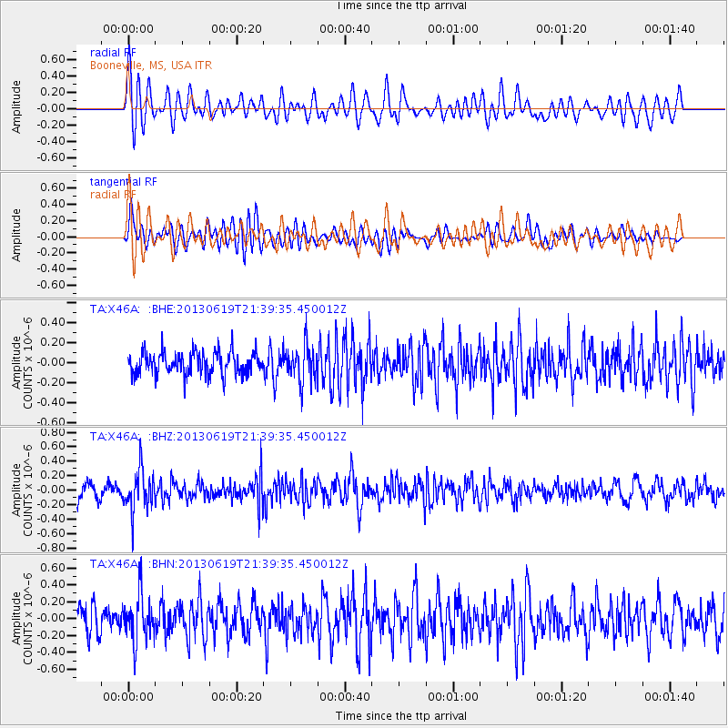
X46A Booneville, MS, USA - Earthquake Result Viewer
*The percent match for this event was below the threshold and hence no stack was calculated.
| Earthquake location: |
Chile-Argentina Border Region |
| Earthquake latitude/longitude: |
-32.7/-70.0 |
| Earthquake time(UTC): |
2013/06/19 (170) 21:29:11 GMT |
| Earthquake Depth: |
104 km |
| Earthquake Magnitude: |
5.5 MB |
| Earthquake Catalog/Contributor: |
NEIC PDE/NEIC PDE-W |
|
| Network: |
TA USArray Transportable Network (new EarthScope stations) |
| Station: |
X46A Booneville, MS, USA |
| Lat/Lon: |
34.56 N/88.58 W |
| Elevation: |
150 m |
|
| Distance: |
69.1 deg |
| Az: |
343.68 deg |
| Baz: |
163.31 deg |
| Ray Param: |
$rayparam |
*The percent match for this event was below the threshold and hence was not used in the summary stack. |
|
| Radial Match: |
55.816067 % |
| Radial Bump: |
400 |
| Transverse Match: |
56.700356 % |
| Transverse Bump: |
400 |
| SOD ConfigId: |
512894 |
| Insert Time: |
2013-09-15 08:28:41.114 +0000 |
| GWidth: |
2.5 |
| Max Bumps: |
400 |
| Tol: |
0.001 |
|
Signal To Noise
| Channel | StoN | STA | LTA |
| TA:X46A: :BHZ:20130619T21:39:35.450012Z | 2.6025636 | 2.7986948E-7 | 1.0753608E-7 |
| TA:X46A: :BHN:20130619T21:39:35.450012Z | 1.6764134 | 2.802444E-7 | 1.6716902E-7 |
| TA:X46A: :BHE:20130619T21:39:35.450012Z | 1.5902736 | 1.8127423E-7 | 1.1398934E-7 |
| Arrivals |
| Ps | |
| PpPs | |
| PsPs/PpSs | |


