You are here: Home > Network List > UW - Pacific Northwest Regional Seismic Network Stations List
> Station LCCR Mulino, OR, USA > Earthquake Result Viewer
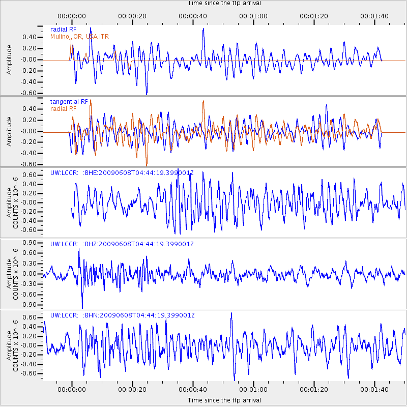
LCCR Mulino, OR, USA - Earthquake Result Viewer
*The percent match for this event was below the threshold and hence no stack was calculated.
| Earthquake location: |
South Of Fiji Islands |
| Earthquake latitude/longitude: |
-22.2/-179.6 |
| Earthquake time(UTC): |
2009/06/08 (159) 04:33:19 GMT |
| Earthquake Depth: |
612 km |
| Earthquake Magnitude: |
5.5 MW, 5.2 MB |
| Earthquake Catalog/Contributor: |
WHDF/NEIC |
|
| Network: |
UW Pacific Northwest Regional Seismic Network |
| Station: |
LCCR Mulino, OR, USA |
| Lat/Lon: |
45.21 N/122.48 W |
| Elevation: |
273 m |
|
| Distance: |
84.9 deg |
| Az: |
36.597 deg |
| Baz: |
231.386 deg |
| Ray Param: |
$rayparam |
*The percent match for this event was below the threshold and hence was not used in the summary stack. |
|
| Radial Match: |
55.086937 % |
| Radial Bump: |
400 |
| Transverse Match: |
58.90478 % |
| Transverse Bump: |
400 |
| SOD ConfigId: |
2648 |
| Insert Time: |
2010-02-27 04:38:50.016 +0000 |
| GWidth: |
2.5 |
| Max Bumps: |
400 |
| Tol: |
0.001 |
|
Signal To Noise
| Channel | StoN | STA | LTA |
| UW:LCCR: :BHZ:20090608T04:44:19.399001Z | 2.8773267 | 3.196347E-7 | 1.1108738E-7 |
| UW:LCCR: :BHN:20090608T04:44:19.399001Z | 1.673986 | 2.6532283E-7 | 1.5849764E-7 |
| UW:LCCR: :BHE:20090608T04:44:19.399001Z | 1.6952802 | 3.3241542E-7 | 1.9608288E-7 |
| Arrivals |
| Ps | |
| PpPs | |
| PsPs/PpSs | |


