You are here: Home > Network List > US - United States National Seismic Network Stations List
> Station DGMT Dagmar, Montana, USA > Earthquake Result Viewer
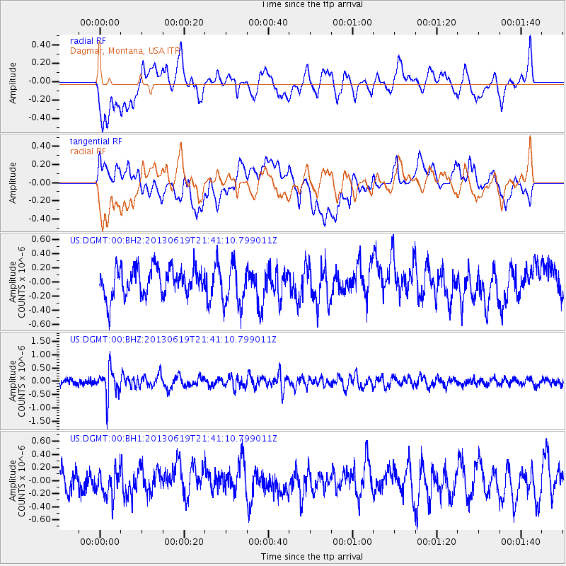
DGMT Dagmar, Montana, USA - Earthquake Result Viewer
*The percent match for this event was below the threshold and hence no stack was calculated.
| Earthquake location: |
Chile-Argentina Border Region |
| Earthquake latitude/longitude: |
-32.7/-70.0 |
| Earthquake time(UTC): |
2013/06/19 (170) 21:29:11 GMT |
| Earthquake Depth: |
104 km |
| Earthquake Magnitude: |
5.5 MB |
| Earthquake Catalog/Contributor: |
NEIC PDE/NEIC PDE-W |
|
| Network: |
US United States National Seismic Network |
| Station: |
DGMT Dagmar, Montana, USA |
| Lat/Lon: |
48.47 N/104.20 W |
| Elevation: |
0.0 m |
|
| Distance: |
86.3 deg |
| Az: |
338.012 deg |
| Baz: |
151.668 deg |
| Ray Param: |
$rayparam |
*The percent match for this event was below the threshold and hence was not used in the summary stack. |
|
| Radial Match: |
52.760452 % |
| Radial Bump: |
400 |
| Transverse Match: |
43.41435 % |
| Transverse Bump: |
400 |
| SOD ConfigId: |
512894 |
| Insert Time: |
2013-09-15 08:30:56.635 +0000 |
| GWidth: |
2.5 |
| Max Bumps: |
400 |
| Tol: |
0.001 |
|
Signal To Noise
| Channel | StoN | STA | LTA |
| US:DGMT:00:BHZ:20130619T21:41:10.799011Z | 5.08091 | 5.3019534E-7 | 1.04350455E-7 |
| US:DGMT:00:BH1:20130619T21:41:10.799011Z | 1.2618397 | 2.174354E-7 | 1.7231616E-7 |
| US:DGMT:00:BH2:20130619T21:41:10.799011Z | 1.5180806 | 2.9845756E-7 | 1.9660192E-7 |
| Arrivals |
| Ps | |
| PpPs | |
| PsPs/PpSs | |


