You are here: Home > Network List > UW - Pacific Northwest Regional Seismic Network Stations List
> Station LCCR Mulino, OR, USA > Earthquake Result Viewer
LCCR Mulino, OR, USA - Earthquake Result Viewer
*The percent match for this event was below the threshold and hence no stack was calculated.
| Earthquake location: |
Mariana Islands |
| Earthquake latitude/longitude: |
14.1/145.2 |
| Earthquake time(UTC): |
2009/06/19 (170) 15:06:24 GMT |
| Earthquake Depth: |
114 km |
| Earthquake Magnitude: |
5.5 MB, 5.5 MW |
| Earthquake Catalog/Contributor: |
WHDF/NEIC |
|
| Network: |
UW Pacific Northwest Regional Seismic Network |
| Station: |
LCCR Mulino, OR, USA |
| Lat/Lon: |
45.21 N/122.48 W |
| Elevation: |
273 m |
|
| Distance: |
81.8 deg |
| Az: |
45.536 deg |
| Baz: |
281.586 deg |
| Ray Param: |
$rayparam |
*The percent match for this event was below the threshold and hence was not used in the summary stack. |
|
| Radial Match: |
52.852802 % |
| Radial Bump: |
400 |
| Transverse Match: |
45.980553 % |
| Transverse Bump: |
400 |
| SOD ConfigId: |
2648 |
| Insert Time: |
2010-02-27 04:39:23.490 +0000 |
| GWidth: |
2.5 |
| Max Bumps: |
400 |
| Tol: |
0.001 |
|
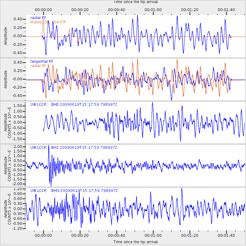
Signal To Noise
| Channel | StoN | STA | LTA |
| UW:LCCR: :BHZ:20090619T15:17:59.798997Z | 4.692327 | 8.417576E-7 | 1.7939023E-7 |
| UW:LCCR: :BHN:20090619T15:17:59.798997Z | 0.44509098 | 1.9249755E-7 | 4.3249034E-7 |
| UW:LCCR: :BHE:20090619T15:17:59.798997Z | 0.7065713 | 3.3093295E-7 | 4.6836453E-7 |
| Arrivals |
| Ps | |
| PpPs | |
| PsPs/PpSs | |


