You are here: Home > Network List > XL12 - Hangay Dome, Mongolia Stations List
> Station HV26 HV26 > Earthquake Result Viewer
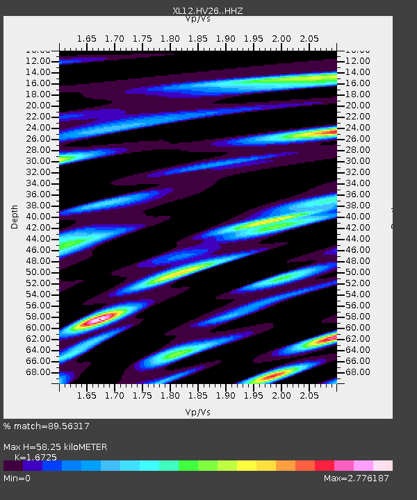
HV26 HV26 - Earthquake Result Viewer
| Earthquake location: |
Iran-Iraq Border Region |
| Earthquake latitude/longitude: |
32.6/47.8 |
| Earthquake time(UTC): |
2014/08/20 (232) 10:14:15 GMT |
| Earthquake Depth: |
10 km |
| Earthquake Magnitude: |
5.7 M |
| Earthquake Catalog/Contributor: |
NEIC PDE/NEIC ALERT |
|
| Network: |
XL Hangay Dome, Mongolia |
| Station: |
HV26 HV26 |
| Lat/Lon: |
50.62 N/101.86 E |
| Elevation: |
1158 m |
|
| Distance: |
43.2 deg |
| Az: |
48.909 deg |
| Baz: |
266.657 deg |
| Ray Param: |
0.07272288 |
| Estimated Moho Depth: |
58.25 km |
| Estimated Crust Vp/Vs: |
1.67 |
| Assumed Crust Vp: |
6.419 km/s |
| Estimated Crust Vs: |
3.838 km/s |
| Estimated Crust Poisson's Ratio: |
0.22 |
|
| Radial Match: |
89.56317 % |
| Radial Bump: |
400 |
| Transverse Match: |
83.247505 % |
| Transverse Bump: |
400 |
| SOD ConfigId: |
3390531 |
| Insert Time: |
2019-04-13 11:57:38.761 +0000 |
| GWidth: |
2.5 |
| Max Bumps: |
400 |
| Tol: |
0.001 |
|

Signal To Noise
| Channel | StoN | STA | LTA |
| XL:HV26: :HHZ:20140820T10:21:46.209009Z | 21.961245 | 6.388701E-7 | 2.9090799E-8 |
| XL:HV26: :HHN:20140820T10:21:46.209009Z | 1.6933323 | 6.3931246E-8 | 3.7754695E-8 |
| XL:HV26: :HHE:20140820T10:21:46.209009Z | 16.01222 | 5.315697E-7 | 3.3197754E-8 |
| Arrivals |
| Ps | 6.5 SECOND |
| PpPs | 23 SECOND |
| PsPs/PpSs | 29 SECOND |


