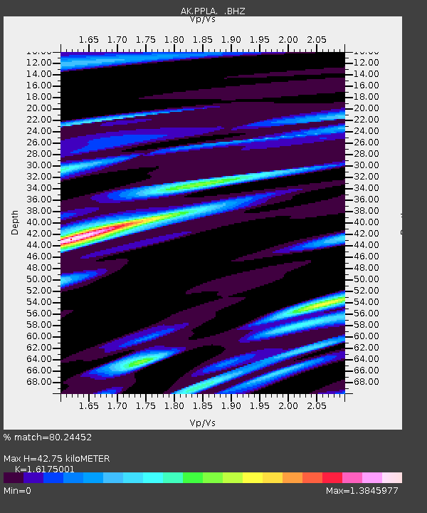
PPLA Purkeypile - Earthquake Result Viewer

Earthquake location: Northern Mid-Atlantic Ridge
Earthquake latitude/longitude: 10.7/-42.6
Earthquake time(UTC): 2013/06/24 (175) 22:04:13 GMT
Earthquake Depth: 10 km
Earthquake Magnitude: 6.5 MW, 6.1 MB, 6.3 MS, 6.6 MW
Earthquake Catalog/Contributor: NEIC PDE/NEIC PDE-W
Network: AK Alaska Regional Network
Station: PPLA Purkeypile
Lat/Lon: 62.90 N/152.19 W
Elevation: 1519 m
Distance: 89.3 deg
Az: 334.435 deg
Baz: 67.821 deg
Ray Param: 0.041985035
Estimated Moho Depth: 42.75 km
Estimated Crust Vp/Vs: 1.62
Assumed Crust Vp: 6.566 km/s
Estimated Crust Vs: 4.059 km/s
Estimated Crust Poisson's Ratio: 0.19
Radial Match: 80.24452 %
Radial Bump: 400
Transverse Match: 70.05674 %
Transverse Bump: 400
SOD ConfigId: 512894
Insert Time: 2013-09-15 09:10:05.628 +0000
GWidth: 2.5
Max Bumps: 400
Tol: 0.001

Signal To Noise

ChannelStoNSTALTA
AK:PPLA: :BHZ:20130624T22:16:38.027974Z4.72650866.1707857E-71.3055696E-7
AK:PPLA: :BHN:20130624T22:16:38.027974Z1.52221182.7666326E-71.8175085E-7
AK:PPLA: :BHE:20130624T22:16:38.027974Z1.71370263.783445E-72.2077606E-7
Arrivals
Ps4.1 SECOND
PpPs17 SECOND
PsPs/PpSs21 SECOND