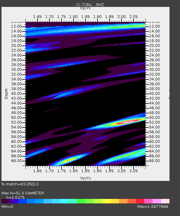
TCBU Trout Creek Butte at 3-Sisters, OR - Earthquake Result Viewer

Earthquake location: Northern Mid-Atlantic Ridge
Earthquake latitude/longitude: 10.7/-42.6
Earthquake time(UTC): 2013/06/24 (175) 22:04:13 GMT
Earthquake Depth: 10 km
Earthquake Magnitude: 6.5 MW, 6.1 MB, 6.3 MS, 6.6 MW
Earthquake Catalog/Contributor: NEIC PDE/NEIC PDE-W
Network: CC Cascade Chain Volcano Monitoring
Station: TCBU Trout Creek Butte at 3-Sisters, OR
Lat/Lon: 44.24 N/121.66 W
Elevation: 1646 m
Distance: 74.8 deg
Az: 313.004 deg
Baz: 89.82 deg
Ray Param: 0.052090693
Estimated Moho Depth: 51.5 km
Estimated Crust Vp/Vs: 2.03
Assumed Crust Vp: 6.597 km/s
Estimated Crust Vs: 3.254 km/s
Estimated Crust Poisson's Ratio: 0.34
Radial Match: 83.05013 %
Radial Bump: 400
Transverse Match: 66.2491 %
Transverse Bump: 400
SOD ConfigId: 512894
Insert Time: 2013-09-15 09:14:24.419 +0000
GWidth: 2.5
Max Bumps: 400
Tol: 0.001

Signal To Noise

ChannelStoNSTALTA
CC:TCBU: :BHZ:20130624T22:15:22.45998Z3.723456.747854E-71.8122586E-7
CC:TCBU: :BHN:20130624T22:15:22.45998Z0.9466382.1499625E-72.271156E-7
CC:TCBU: :BHE:20130624T22:15:22.45998Z2.7647825.19431E-71.8787414E-7
Arrivals
Ps8.3 SECOND
PpPs23 SECOND
PsPs/PpSs31 SECOND