You are here: Home > Network List > UW - Pacific Northwest Regional Seismic Network Stations List
> Station LEBA Lebam, WA, USA > Earthquake Result Viewer
LEBA Lebam, WA, USA - Earthquake Result Viewer
| Earthquake location: |
Off Coast Of Jalisco, Mexico |
| Earthquake latitude/longitude: |
18.8/-107.3 |
| Earthquake time(UTC): |
2009/09/24 (267) 07:16:19 GMT |
| Earthquake Depth: |
10 km |
| Earthquake Magnitude: |
5.8 MB, 6.2 MS, 6.3 MW, 6.3 MW |
| Earthquake Catalog/Contributor: |
WHDF/NEIC |
|
| Network: |
UW Pacific Northwest Regional Seismic Network |
| Station: |
LEBA Lebam, WA, USA |
| Lat/Lon: |
46.55 N/123.56 W |
| Elevation: |
73 m |
|
| Distance: |
30.7 deg |
| Az: |
337.821 deg |
| Baz: |
148.798 deg |
| Ray Param: |
0.07926145 |
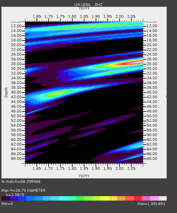
| Estimated Moho Depth: |
26.75 km |
| Estimated Crust Vp/Vs: |
2.10 |
| Assumed Crust Vp: |
6.566 km/s |
| Estimated Crust Vs: |
3.13 km/s |
| Estimated Crust Poisson's Ratio: |
0.35 |
|
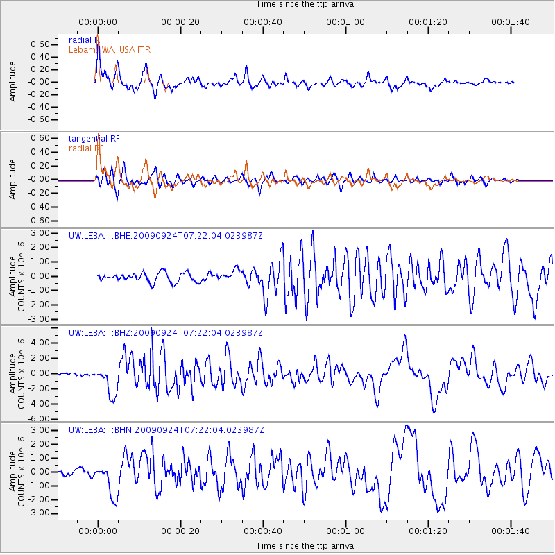
| Radial Match: |
86.289566 % |
| Radial Bump: |
353 |
| Transverse Match: |
82.682556 % |
| Transverse Bump: |
400 |
| SOD ConfigId: |
2622 |
| Insert Time: |
2010-02-27 04:40:23.661 +0000 |
| GWidth: |
2.5 |
| Max Bumps: |
400 |
| Tol: |
0.001 |
|
Signal To Noise
| Channel | StoN | STA | LTA |
| UW:LEBA: :BHZ:20090924T07:22:04.023987Z | 10.221432 | 1.9855959E-6 | 1.9425809E-7 |
| UW:LEBA: :BHN:20090924T07:22:04.023987Z | 5.7319508 | 1.2571132E-6 | 2.1931682E-7 |
| UW:LEBA: :BHE:20090924T07:22:04.023987Z | 1.2960727 | 4.0289447E-7 | 3.108579E-7 |
| Arrivals |
| Ps | 4.8 SECOND |
| PpPs | 12 SECOND |
| PsPs/PpSs | 17 SECOND |


