You are here: Home > Network List > UW - Pacific Northwest Regional Seismic Network Stations List
> Station LEBA Lebam, WA, USA > Earthquake Result Viewer
LEBA Lebam, WA, USA - Earthquake Result Viewer
| Earthquake location: |
Vanuatu Islands |
| Earthquake latitude/longitude: |
-13.0/166.5 |
| Earthquake time(UTC): |
2009/10/07 (280) 22:03:14 GMT |
| Earthquake Depth: |
45 km |
| Earthquake Magnitude: |
6.4 MB, 7.3 MS, 7.6 MW, 7.7 MW |
| Earthquake Catalog/Contributor: |
WHDF/NEIC |
|
| Network: |
UW Pacific Northwest Regional Seismic Network |
| Station: |
LEBA Lebam, WA, USA |
| Lat/Lon: |
46.55 N/123.56 W |
| Elevation: |
73 m |
|
| Distance: |
86.0 deg |
| Az: |
40.529 deg |
| Baz: |
246.587 deg |
| Ray Param: |
0.044264406 |
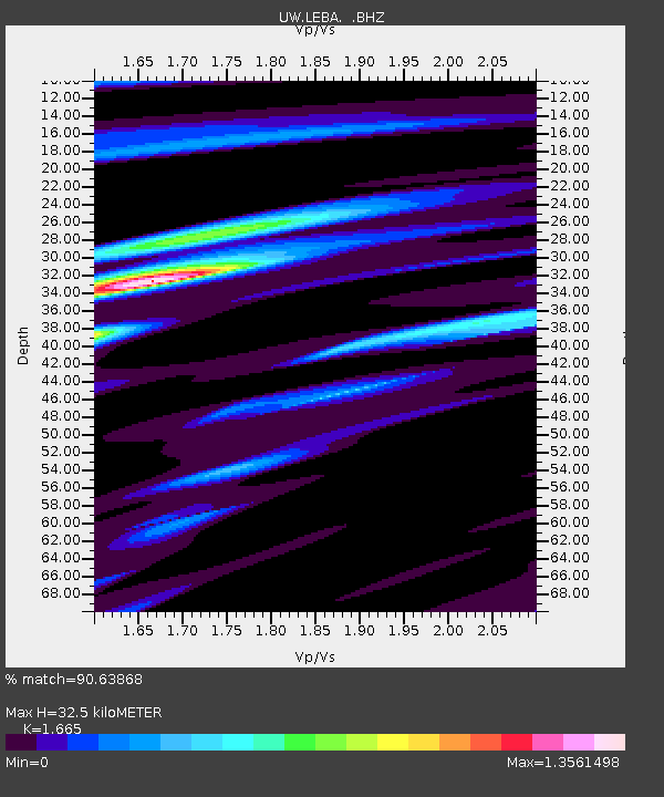
| Estimated Moho Depth: |
32.5 km |
| Estimated Crust Vp/Vs: |
1.66 |
| Assumed Crust Vp: |
6.566 km/s |
| Estimated Crust Vs: |
3.944 km/s |
| Estimated Crust Poisson's Ratio: |
0.22 |
|
| Radial Match: |
90.63868 % |
| Radial Bump: |
400 |
| Transverse Match: |
83.39292 % |
| Transverse Bump: |
400 |
| SOD ConfigId: |
2622 |
| Insert Time: |
2010-02-27 04:40:25.916 +0000 |
| GWidth: |
2.5 |
| Max Bumps: |
400 |
| Tol: |
0.001 |
|
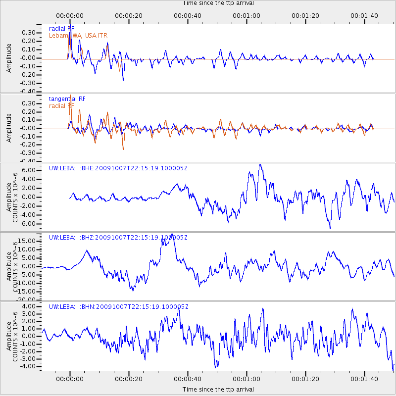
Signal To Noise
| Channel | StoN | STA | LTA |
| UW:LEBA: :BHZ:20091007T22:15:19.100005Z | 7.441162 | 2.8893576E-6 | 3.8829387E-7 |
| UW:LEBA: :BHN:20091007T22:15:19.100005Z | 0.9309253 | 3.885553E-7 | 4.173861E-7 |
| UW:LEBA: :BHE:20091007T22:15:19.100005Z | 2.7816827 | 1.153656E-6 | 4.147331E-7 |
| Arrivals |
| Ps | 3.4 SECOND |
| PpPs | 13 SECOND |
| PsPs/PpSs | 16 SECOND |


