You are here: Home > Network List > II - Global Seismograph Network (GSN - IRIS/IDA) Stations List
> Station KAPI Kappang, Sulawesi, Indonesia > Earthquake Result Viewer
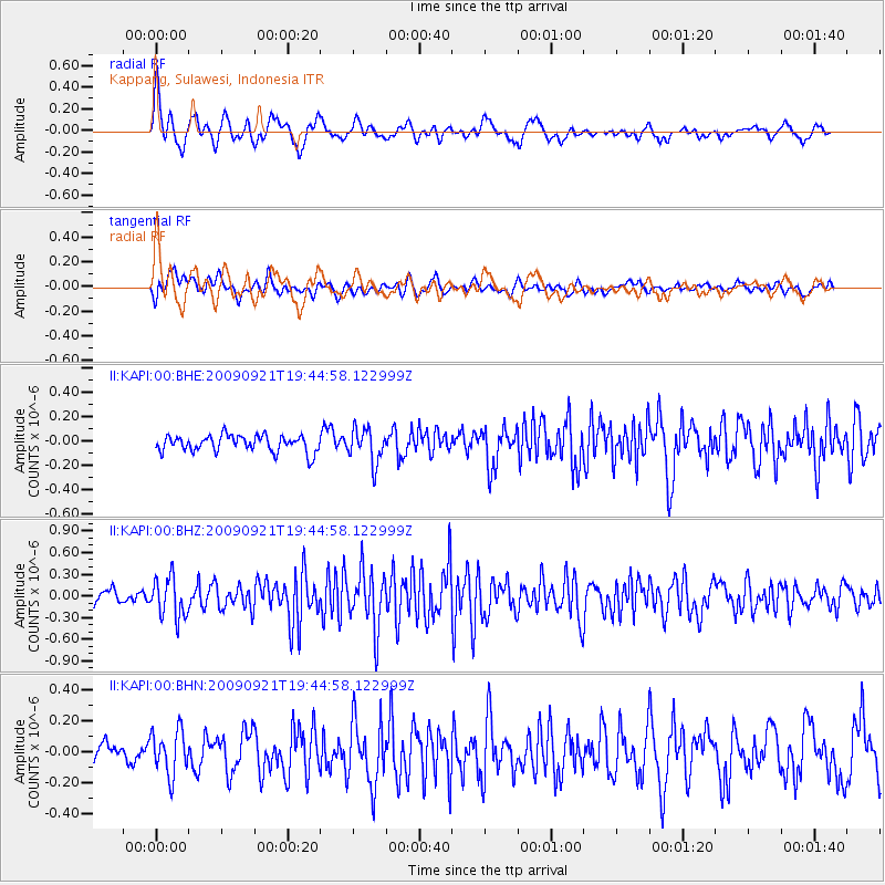
KAPI Kappang, Sulawesi, Indonesia - Earthquake Result Viewer
*The percent match for this event was below the threshold and hence no stack was calculated.
| Earthquake location: |
Myanmar |
| Earthquake latitude/longitude: |
20.4/94.8 |
| Earthquake time(UTC): |
2009/09/21 (264) 19:38:42 GMT |
| Earthquake Depth: |
84 km |
| Earthquake Magnitude: |
5.6 MB, 5.7 MW, 5.6 MW |
| Earthquake Catalog/Contributor: |
WHDF/NEIC |
|
| Network: |
II Global Seismograph Network (GSN - IRIS/IDA) |
| Station: |
KAPI Kappang, Sulawesi, Indonesia |
| Lat/Lon: |
5.01 S/119.75 E |
| Elevation: |
300 m |
|
| Distance: |
35.2 deg |
| Az: |
133.179 deg |
| Baz: |
316.638 deg |
| Ray Param: |
$rayparam |
*The percent match for this event was below the threshold and hence was not used in the summary stack. |
|
| Radial Match: |
74.006836 % |
| Radial Bump: |
400 |
| Transverse Match: |
62.835857 % |
| Transverse Bump: |
400 |
| SOD ConfigId: |
1 |
| Insert Time: |
2010-02-19 00:18:08.755 +0000 |
| GWidth: |
2.5 |
| Max Bumps: |
400 |
| Tol: |
0.001 |
|
Signal To Noise
| Channel | StoN | STA | LTA |
| II:KAPI:00:BHZ:20090921T19:44:58.122999Z | 3.2786071 | 2.745614E-7 | 8.374331E-8 |
| II:KAPI:00:BHN:20090921T19:44:58.122999Z | 1.9936122 | 1.433924E-7 | 7.1925925E-8 |
| II:KAPI:00:BHE:20090921T19:44:58.122999Z | 2.0479407 | 1.3825755E-7 | 6.751053E-8 |
| Arrivals |
| Ps | |
| PpPs | |
| PsPs/PpSs | |


