You are here: Home > Network List > UW - Pacific Northwest Regional Seismic Network Stations List
> Station LEBA Lebam, WA, USA > Earthquake Result Viewer
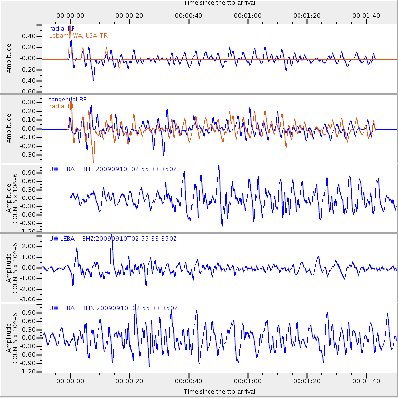
LEBA Lebam, WA, USA - Earthquake Result Viewer
*The percent match for this event was below the threshold and hence no stack was calculated.
| Earthquake location: |
Kuril Islands |
| Earthquake latitude/longitude: |
48.3/154.2 |
| Earthquake time(UTC): |
2009/09/10 (253) 02:46:50 GMT |
| Earthquake Depth: |
36 km |
| Earthquake Magnitude: |
6.0 MB, 5.5 MS, 6.0 MW, 5.8 MW |
| Earthquake Catalog/Contributor: |
WHDF/NEIC |
|
| Network: |
UW Pacific Northwest Regional Seismic Network |
| Station: |
LEBA Lebam, WA, USA |
| Lat/Lon: |
46.55 N/123.56 W |
| Elevation: |
73 m |
|
| Distance: |
53.1 deg |
| Az: |
58.832 deg |
| Baz: |
304.157 deg |
| Ray Param: |
$rayparam |
*The percent match for this event was below the threshold and hence was not used in the summary stack. |
|
| Radial Match: |
68.051544 % |
| Radial Bump: |
400 |
| Transverse Match: |
74.72752 % |
| Transverse Bump: |
400 |
| SOD ConfigId: |
2622 |
| Insert Time: |
2010-02-27 04:41:05.053 +0000 |
| GWidth: |
2.5 |
| Max Bumps: |
400 |
| Tol: |
0.001 |
|
Signal To Noise
| Channel | StoN | STA | LTA |
| UW:LEBA: :BHZ:20090910T02:55:33.350Z | 5.103369 | 7.644362E-7 | 1.497905E-7 |
| UW:LEBA: :BHN:20090910T02:55:33.350Z | 0.9067594 | 1.8909267E-7 | 2.0853678E-7 |
| UW:LEBA: :BHE:20090910T02:55:33.350Z | 1.03415 | 2.001951E-7 | 1.935842E-7 |
| Arrivals |
| Ps | |
| PpPs | |
| PsPs/PpSs | |


