You are here: Home > Network List > UW - Pacific Northwest Regional Seismic Network Stations List
> Station LEBA Lebam, WA, USA > Earthquake Result Viewer
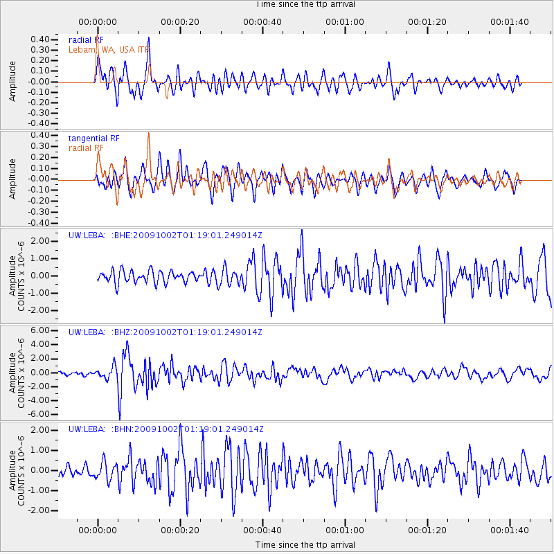
LEBA Lebam, WA, USA - Earthquake Result Viewer
*The percent match for this event was below the threshold and hence no stack was calculated.
| Earthquake location: |
Tonga Islands |
| Earthquake latitude/longitude: |
-16.3/-173.5 |
| Earthquake time(UTC): |
2009/10/02 (275) 01:07:39 GMT |
| Earthquake Depth: |
8.0 km |
| Earthquake Magnitude: |
6.1 MB, 6.0 MS, 6.1 MW, 6.1 MW |
| Earthquake Catalog/Contributor: |
WHDF/NEIC |
|
| Network: |
UW Pacific Northwest Regional Seismic Network |
| Station: |
LEBA Lebam, WA, USA |
| Lat/Lon: |
46.55 N/123.56 W |
| Elevation: |
73 m |
|
| Distance: |
77.0 deg |
| Az: |
32.809 deg |
| Baz: |
228.917 deg |
| Ray Param: |
$rayparam |
*The percent match for this event was below the threshold and hence was not used in the summary stack. |
|
| Radial Match: |
82.309425 % |
| Radial Bump: |
400 |
| Transverse Match: |
75.58681 % |
| Transverse Bump: |
400 |
| SOD ConfigId: |
2622 |
| Insert Time: |
2010-02-27 04:41:13.549 +0000 |
| GWidth: |
2.5 |
| Max Bumps: |
400 |
| Tol: |
0.001 |
|
Signal To Noise
| Channel | StoN | STA | LTA |
| UW:LEBA: :BHZ:20091002T01:19:01.249014Z | 3.2565985 | 8.3966796E-7 | 2.578359E-7 |
| UW:LEBA: :BHN:20091002T01:19:01.249014Z | 1.2250394 | 4.3759252E-7 | 3.572069E-7 |
| UW:LEBA: :BHE:20091002T01:19:01.249014Z | 1.4033574 | 4.669426E-7 | 3.3273247E-7 |
| Arrivals |
| Ps | |
| PpPs | |
| PsPs/PpSs | |


