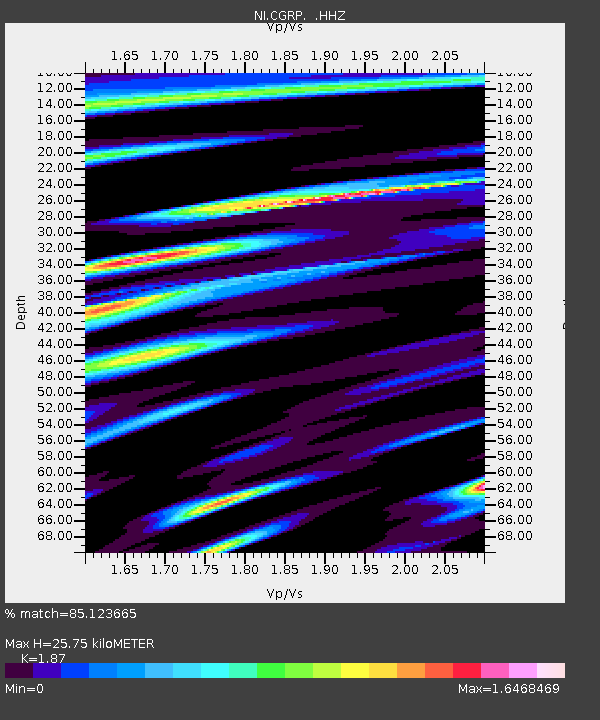
CGRP Cima Grappa - Earthquake Result Viewer

Earthquake location: Northern Mid-Atlantic Ridge
Earthquake latitude/longitude: 10.7/-42.6
Earthquake time(UTC): 2013/06/24 (175) 22:04:13 GMT
Earthquake Depth: 10 km
Earthquake Magnitude: 6.5 MW, 6.1 MB, 6.3 MS, 6.6 MW
Earthquake Catalog/Contributor: NEIC PDE/NEIC PDE-W
Network: NI North-East Italy Broadband Network
Station: CGRP Cima Grappa
Lat/Lon: 45.88 N/11.80 E
Elevation: 1757 m
Distance: 57.9 deg
Az: 42.117 deg
Baz: 250.657 deg
Ray Param: 0.06320796
Estimated Moho Depth: 25.75 km
Estimated Crust Vp/Vs: 1.87
Assumed Crust Vp: 6.155 km/s
Estimated Crust Vs: 3.291 km/s
Estimated Crust Poisson's Ratio: 0.30
Radial Match: 85.123665 %
Radial Bump: 400
Transverse Match: 73.96757 %
Transverse Bump: 400
SOD ConfigId: 512894
Insert Time: 2013-09-15 09:28:16.496 +0000
GWidth: 2.5
Max Bumps: 400
Tol: 0.001

Signal To Noise

ChannelStoNSTALTA
NI:CGRP: :HHZ:20130624T22:13:34.328022Z31.3667813.405273E-61.08563036E-7
NI:CGRP: :HHN:20130624T22:13:34.328022Z9.398681.2411348E-61.3205415E-7
NI:CGRP: :HHE:20130624T22:13:34.328022Z3.9710089.3705677E-72.3597454E-7
Arrivals
Ps3.8 SECOND
PpPs12 SECOND
PsPs/PpSs15 SECOND