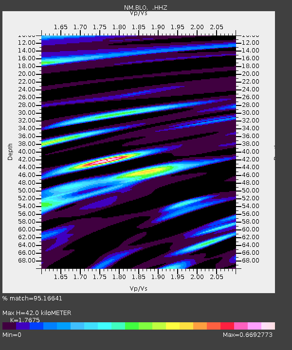
BLO Bloomington, IN - Earthquake Result Viewer

Earthquake location: Northern Mid-Atlantic Ridge
Earthquake latitude/longitude: 10.7/-42.6
Earthquake time(UTC): 2013/06/24 (175) 22:04:13 GMT
Earthquake Depth: 10 km
Earthquake Magnitude: 6.5 MW, 6.1 MB, 6.3 MS, 6.6 MW
Earthquake Catalog/Contributor: NEIC PDE/NEIC PDE-W
Network: NM Cooperative New Madrid Seismic Network
Station: BLO Bloomington, IN
Lat/Lon: 39.17 N/86.52 W
Elevation: 246 m
Distance: 48.2 deg
Az: 313.682 deg
Baz: 113.882 deg
Ray Param: 0.06949996
Estimated Moho Depth: 42.0 km
Estimated Crust Vp/Vs: 1.77
Assumed Crust Vp: 6.444 km/s
Estimated Crust Vs: 3.646 km/s
Estimated Crust Poisson's Ratio: 0.26
Radial Match: 95.16641 %
Radial Bump: 333
Transverse Match: 80.04661 %
Transverse Bump: 400
SOD ConfigId: 512894
Insert Time: 2013-09-15 09:28:42.136 +0000
GWidth: 2.5
Max Bumps: 400
Tol: 0.001

Signal To Noise

ChannelStoNSTALTA
NM:BLO: :HHZ:20130624T22:12:23.227986Z10.3135659.4444323E-79.1572915E-8
NM:BLO: :HHN:20130624T22:12:23.227986Z2.9596121.7861888E-76.035213E-8
NM:BLO: :HHE:20130624T22:12:23.227986Z6.90903763.795157E-75.4930325E-8
Arrivals
Ps5.3 SECOND
PpPs17 SECOND
PsPs/PpSs22 SECOND