You are here: Home > Network List > UW - Pacific Northwest Regional Seismic Network Stations List
> Station LEBA Lebam, WA, USA > Earthquake Result Viewer
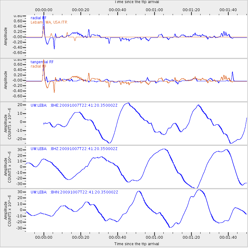
LEBA Lebam, WA, USA - Earthquake Result Viewer
*The percent match for this event was below the threshold and hence no stack was calculated.
| Earthquake location: |
Santa Cruz Islands |
| Earthquake latitude/longitude: |
-11.5/166.0 |
| Earthquake time(UTC): |
2009/10/07 (280) 22:29:18 GMT |
| Earthquake Depth: |
35 km |
| Earthquake Magnitude: |
5.5 MB |
| Earthquake Catalog/Contributor: |
WHDF/NEIC |
|
| Network: |
UW Pacific Northwest Regional Seismic Network |
| Station: |
LEBA Lebam, WA, USA |
| Lat/Lon: |
46.55 N/123.56 W |
| Elevation: |
73 m |
|
| Distance: |
85.2 deg |
| Az: |
40.731 deg |
| Baz: |
247.917 deg |
| Ray Param: |
$rayparam |
*The percent match for this event was below the threshold and hence was not used in the summary stack. |
|
| Radial Match: |
86.24002 % |
| Radial Bump: |
400 |
| Transverse Match: |
52.14109 % |
| Transverse Bump: |
400 |
| SOD ConfigId: |
2622 |
| Insert Time: |
2010-02-27 04:41:21.559 +0000 |
| GWidth: |
2.5 |
| Max Bumps: |
400 |
| Tol: |
0.001 |
|
Signal To Noise
| Channel | StoN | STA | LTA |
| UW:LEBA: :BHZ:20091007T22:41:20.350002Z | 2.635784 | 1.3128776E-5 | 4.980976E-6 |
| UW:LEBA: :BHN:20091007T22:41:20.350002Z | 0.92459965 | 7.3685774E-6 | 7.969479E-6 |
| UW:LEBA: :BHE:20091007T22:41:20.350002Z | 3.3133607 | 1.9417443E-5 | 5.860347E-6 |
| Arrivals |
| Ps | |
| PpPs | |
| PsPs/PpSs | |


