You are here: Home > Network List > UW - Pacific Northwest Regional Seismic Network Stations List
> Station LEBA Lebam, WA, USA > Earthquake Result Viewer
LEBA Lebam, WA, USA - Earthquake Result Viewer
*The percent match for this event was below the threshold and hence no stack was calculated.
| Earthquake location: |
Southeast Of Loyalty Islands |
| Earthquake latitude/longitude: |
-22.0/170.2 |
| Earthquake time(UTC): |
2009/10/11 (284) 03:12:13 GMT |
| Earthquake Depth: |
10 km |
| Earthquake Magnitude: |
5.7 MB, 5.5 MS, 6.0 MW, 5.9 MW |
| Earthquake Catalog/Contributor: |
WHDF/NEIC |
|
| Network: |
UW Pacific Northwest Regional Seismic Network |
| Station: |
LEBA Lebam, WA, USA |
| Lat/Lon: |
46.55 N/123.56 W |
| Elevation: |
73 m |
|
| Distance: |
90.6 deg |
| Az: |
39.16 deg |
| Baz: |
238.115 deg |
| Ray Param: |
$rayparam |
*The percent match for this event was below the threshold and hence was not used in the summary stack. |
|
| Radial Match: |
55.448177 % |
| Radial Bump: |
400 |
| Transverse Match: |
49.969624 % |
| Transverse Bump: |
400 |
| SOD ConfigId: |
2622 |
| Insert Time: |
2010-02-27 04:41:24.309 +0000 |
| GWidth: |
2.5 |
| Max Bumps: |
400 |
| Tol: |
0.001 |
|
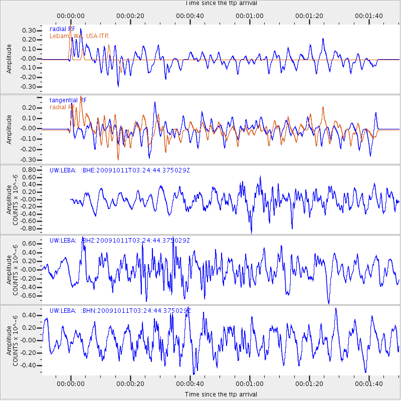
Signal To Noise
| Channel | StoN | STA | LTA |
| UW:LEBA: :BHZ:20091011T03:24:44.375029Z | 2.1625032 | 3.5956697E-7 | 1.662735E-7 |
| UW:LEBA: :BHN:20091011T03:24:44.375029Z | 0.48883268 | 1.09773815E-7 | 2.2456318E-7 |
| UW:LEBA: :BHE:20091011T03:24:44.375029Z | 1.7038355 | 2.6148436E-7 | 1.5346808E-7 |
| Arrivals |
| Ps | |
| PpPs | |
| PsPs/PpSs | |


