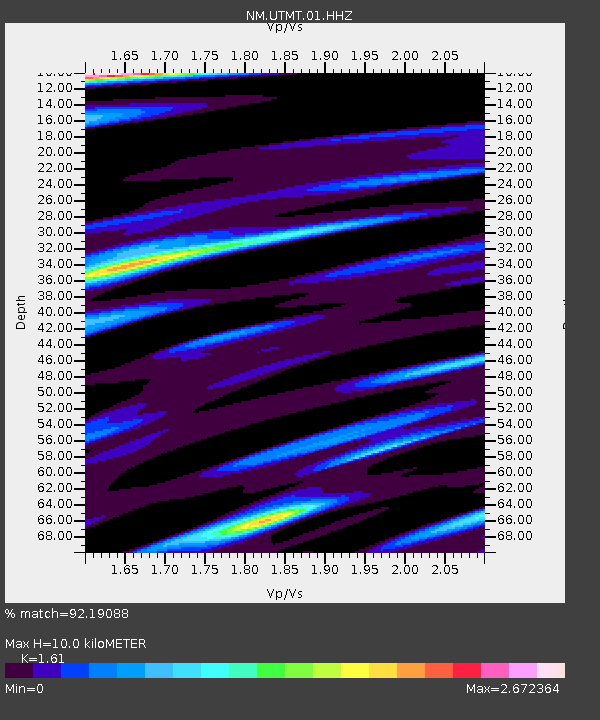
UTMT Martin, TN - Earthquake Result Viewer
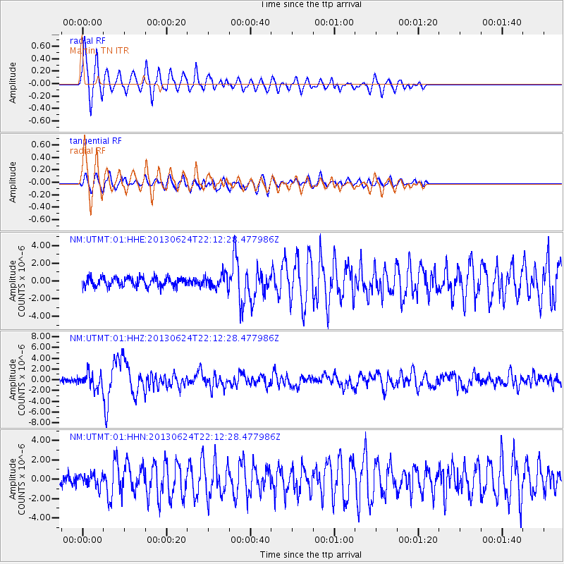
Earthquake location: Northern Mid-Atlantic Ridge
Earthquake latitude/longitude: 10.7/-42.6
Earthquake time(UTC): 2013/06/24 (175) 22:04:13 GMT
Earthquake Depth: 10 km
Earthquake Magnitude: 6.5 MW, 6.1 MB, 6.3 MS, 6.6 MW
Earthquake Catalog/Contributor: NEIC PDE/NEIC PDE-W
Network: NM Cooperative New Madrid Seismic Network
Station: UTMT Martin, TN
Lat/Lon: 36.35 N/88.86 W
Elevation: 110 m
Distance: 48.9 deg
Az: 309.275 deg
Baz: 109.536 deg
Ray Param: 0.069052234
Estimated Moho Depth: 10.0 km
Estimated Crust Vp/Vs: 1.61
Assumed Crust Vp: 6.444 km/s
Estimated Crust Vs: 4.002 km/s
Estimated Crust Poisson's Ratio: 0.19
Radial Match: 92.19088 %
Radial Bump: 394
Transverse Match: 73.83095 %
Transverse Bump: 400
SOD ConfigId: 512894
Insert Time: 2013-09-15 09:29:34.231 +0000
GWidth: 2.5
Max Bumps: 400
Tol: 0.001

Signal To Noise

ChannelStoNSTALTA
NM:UTMT:01:HHZ:20130624T22:12:28.477986Z4.20040041.3795528E-63.2843366E-7
NM:UTMT:01:HHN:20130624T22:12:28.477986Z1.61386556.4451825E-73.9936305E-7
NM:UTMT:01:HHE:20130624T22:12:28.477986Z1.57620997.8934335E-75.007857E-7
Arrivals
Ps1.0 SECOND
PpPs3.8 SECOND
PsPs/PpSs4.8 SECOND