You are here: Home > Network List > UW - Pacific Northwest Regional Seismic Network Stations List
> Station LEBA Lebam, WA, USA > Earthquake Result Viewer
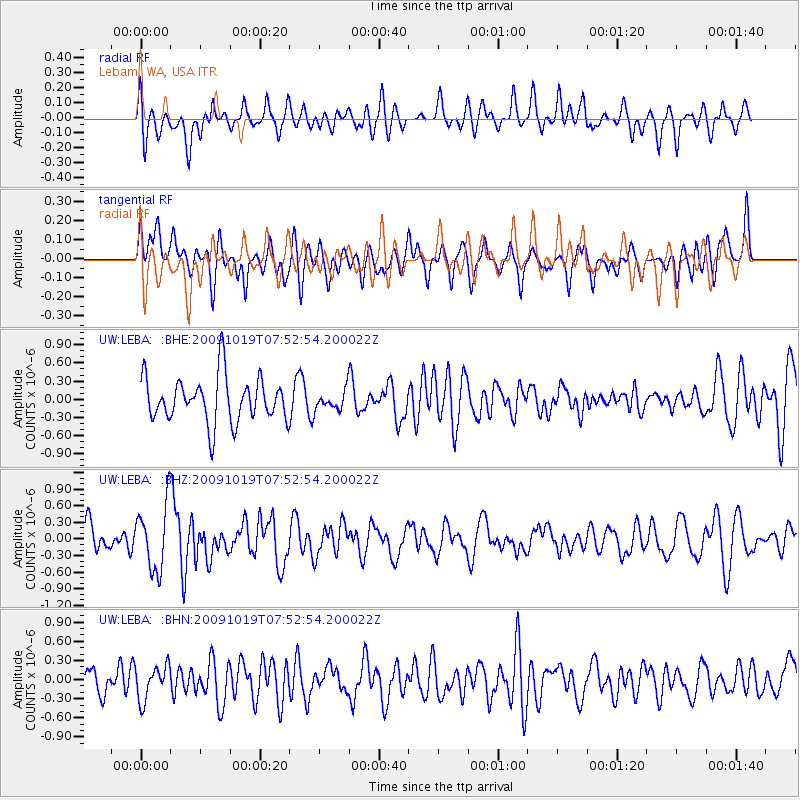
LEBA Lebam, WA, USA - Earthquake Result Viewer
*The percent match for this event was below the threshold and hence no stack was calculated.
| Earthquake location: |
Samoa Islands Region |
| Earthquake latitude/longitude: |
-15.4/-173.0 |
| Earthquake time(UTC): |
2009/10/19 (292) 07:41:38 GMT |
| Earthquake Depth: |
10 km |
| Earthquake Magnitude: |
5.8 MW, 5.4 MS, 5.4 MB, 5.8 MW |
| Earthquake Catalog/Contributor: |
WHDF/NEIC |
|
| Network: |
UW Pacific Northwest Regional Seismic Network |
| Station: |
LEBA Lebam, WA, USA |
| Lat/Lon: |
46.55 N/123.56 W |
| Elevation: |
73 m |
|
| Distance: |
76.0 deg |
| Az: |
32.695 deg |
| Baz: |
229.002 deg |
| Ray Param: |
$rayparam |
*The percent match for this event was below the threshold and hence was not used in the summary stack. |
|
| Radial Match: |
56.283215 % |
| Radial Bump: |
337 |
| Transverse Match: |
49.040886 % |
| Transverse Bump: |
400 |
| SOD ConfigId: |
2622 |
| Insert Time: |
2010-02-27 04:41:42.779 +0000 |
| GWidth: |
2.5 |
| Max Bumps: |
400 |
| Tol: |
0.001 |
|
Signal To Noise
| Channel | StoN | STA | LTA |
| UW:LEBA: :BHZ:20091019T07:52:54.200022Z | 2.2286804 | 5.905832E-7 | 2.6499234E-7 |
| UW:LEBA: :BHN:20091019T07:52:54.200022Z | 0.980752 | 2.681465E-7 | 2.7340909E-7 |
| UW:LEBA: :BHE:20091019T07:52:54.200022Z | 0.4282538 | 1.6027606E-7 | 3.7425485E-7 |
| Arrivals |
| Ps | |
| PpPs | |
| PsPs/PpSs | |


