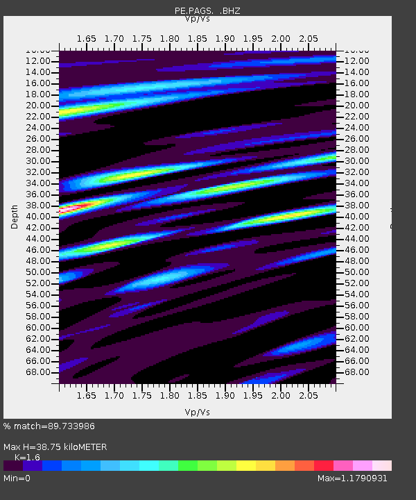
PAGS PA Geological Survey - Earthquake Result Viewer
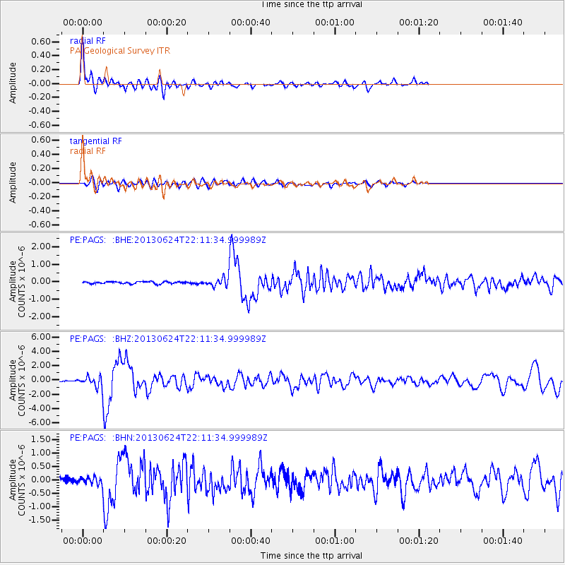
Earthquake location: Northern Mid-Atlantic Ridge
Earthquake latitude/longitude: 10.7/-42.6
Earthquake time(UTC): 2013/06/24 (175) 22:04:13 GMT
Earthquake Depth: 10 km
Earthquake Magnitude: 6.5 MW, 6.1 MB, 6.3 MS, 6.6 MW
Earthquake Catalog/Contributor: NEIC PDE/NEIC PDE-W
Network: PE Penn State Network
Station: PAGS PA Geological Survey
Lat/Lon: 40.23 N/76.72 W
Elevation: 120 m
Distance: 42.1 deg
Az: 320.188 deg
Baz: 124.722 deg
Ray Param: 0.073348835
Estimated Moho Depth: 38.75 km
Estimated Crust Vp/Vs: 1.60
Assumed Crust Vp: 6.121 km/s
Estimated Crust Vs: 3.825 km/s
Estimated Crust Poisson's Ratio: 0.18
Radial Match: 89.733986 %
Radial Bump: 400
Transverse Match: 73.94099 %
Transverse Bump: 400
SOD ConfigId: 512894
Insert Time: 2013-09-15 09:31:29.941 +0000
GWidth: 2.5
Max Bumps: 400
Tol: 0.001

Signal To Noise

ChannelStoNSTALTA
PE:PAGS: :BHZ:20130624T22:11:34.999989Z9.83976657.6380627E-77.7624435E-8
PE:PAGS: :BHN:20130624T22:11:34.999989Z1.96668861.3696722E-76.964357E-8
PE:PAGS: :BHE:20130624T22:11:34.999989Z3.88724372.2694654E-75.838238E-8
Arrivals
Ps4.1 SECOND
PpPs15 SECOND
PsPs/PpSs19 SECOND