You are here: Home > Network List > TA - USArray Transportable Network (new EarthScope stations) Stations List
> Station O03E Paynes Creek, CA, USA > Earthquake Result Viewer
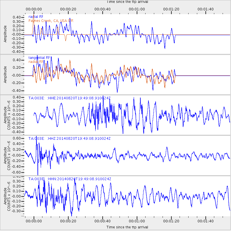
O03E Paynes Creek, CA, USA - Earthquake Result Viewer
*The percent match for this event was below the threshold and hence no stack was calculated.
| Earthquake location: |
Southeast Of Honshu, Japan |
| Earthquake latitude/longitude: |
33.2/138.1 |
| Earthquake time(UTC): |
2014/08/20 (232) 19:38:25 GMT |
| Earthquake Depth: |
308 km |
| Earthquake Magnitude: |
5.4 MW, 5.2 mb |
| Earthquake Catalog/Contributor: |
ISC/ISC |
|
| Network: |
TA USArray Transportable Network (new EarthScope stations) |
| Station: |
O03E Paynes Creek, CA, USA |
| Lat/Lon: |
40.29 N/121.80 W |
| Elevation: |
967 m |
|
| Distance: |
76.2 deg |
| Az: |
50.849 deg |
| Baz: |
301.777 deg |
| Ray Param: |
$rayparam |
*The percent match for this event was below the threshold and hence was not used in the summary stack. |
|
| Radial Match: |
47.94481 % |
| Radial Bump: |
400 |
| Transverse Match: |
52.8527 % |
| Transverse Bump: |
400 |
| SOD ConfigId: |
3390531 |
| Insert Time: |
2019-04-13 12:05:28.639 +0000 |
| GWidth: |
2.5 |
| Max Bumps: |
400 |
| Tol: |
0.001 |
|
Signal To Noise
| Channel | StoN | STA | LTA |
| TA:O03E: :HHZ:20140820T19:49:08.910024Z | 2.8365195 | 2.8052682E-7 | 9.8898255E-8 |
| TA:O03E: :HHN:20140820T19:49:08.910024Z | 1.4872551 | 1.4293659E-7 | 9.610765E-8 |
| TA:O03E: :HHE:20140820T19:49:08.910024Z | 1.3297441 | 1.4504819E-7 | 1.0907978E-7 |
| Arrivals |
| Ps | |
| PpPs | |
| PsPs/PpSs | |


