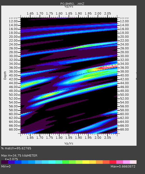
BMRO Maryville Lake, ON, CANADA.A - Earthquake Result Viewer

Earthquake location: Northern Mid-Atlantic Ridge
Earthquake latitude/longitude: 10.7/-42.6
Earthquake time(UTC): 2013/06/24 (175) 22:04:13 GMT
Earthquake Depth: 10 km
Earthquake Magnitude: 6.5 MW, 6.1 MB, 6.3 MS, 6.6 MW
Earthquake Catalog/Contributor: NEIC PDE/NEIC PDE-W
Network: PO Portable Observatories for Lithospheric Analysis and Research Investigating Seis
Station: BMRO Maryville Lake, ON, CANADA.A
Lat/Lon: 44.60 N/81.22 W
Elevation: 217 m
Distance: 47.3 deg
Az: 322.668 deg
Baz: 123.462 deg
Ray Param: 0.07005621
Estimated Moho Depth: 34.75 km
Estimated Crust Vp/Vs: 2.08
Assumed Crust Vp: 6.53 km/s
Estimated Crust Vs: 3.147 km/s
Estimated Crust Poisson's Ratio: 0.35
Radial Match: 95.62765 %
Radial Bump: 260
Transverse Match: 76.63974 %
Transverse Bump: 400
SOD ConfigId: 512894
Insert Time: 2013-09-15 09:32:12.743 +0000
GWidth: 2.5
Max Bumps: 400
Tol: 0.001

Signal To Noise

ChannelStoNSTALTA
PO:BMRO: :HHZ:20130624T22:12:16.420002Z22.9371171.6945387E-67.387758E-8
PO:BMRO: :HHN:20130624T22:12:16.420002Z6.0830375.8939884E-79.68922E-8
PO:BMRO: :HHE:20130624T22:12:16.420002Z13.1484467.787602E-75.9228302E-8
Arrivals
Ps6.0 SECOND
PpPs16 SECOND
PsPs/PpSs22 SECOND