You are here: Home > Network List > TA - USArray Transportable Network (new EarthScope stations) Stations List
> Station 148A Greensboro, AL, USA > Earthquake Result Viewer
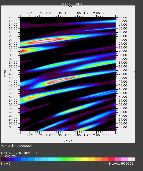
148A Greensboro, AL, USA - Earthquake Result Viewer
| Earthquake location: |
Northern Mid-Atlantic Ridge |
| Earthquake latitude/longitude: |
10.7/-42.6 |
| Earthquake time(UTC): |
2013/06/24 (175) 22:04:13 GMT |
| Earthquake Depth: |
10 km |
| Earthquake Magnitude: |
6.5 MW, 6.1 MB, 6.3 MS, 6.6 MW |
| Earthquake Catalog/Contributor: |
NEIC PDE/NEIC PDE-W |
|
| Network: |
TA USArray Transportable Network (new EarthScope stations) |
| Station: |
148A Greensboro, AL, USA |
| Lat/Lon: |
32.65 N/87.57 W |
| Elevation: |
63 m |
|
| Distance: |
46.7 deg |
| Az: |
305.002 deg |
| Baz: |
107.395 deg |
| Ray Param: |
0.07046974 |
| Estimated Moho Depth: |
22.25 km |
| Estimated Crust Vp/Vs: |
1.73 |
| Assumed Crust Vp: |
6.565 km/s |
| Estimated Crust Vs: |
3.795 km/s |
| Estimated Crust Poisson's Ratio: |
0.25 |
|
| Radial Match: |
94.008224 % |
| Radial Bump: |
400 |
| Transverse Match: |
85.608536 % |
| Transverse Bump: |
400 |
| SOD ConfigId: |
512894 |
| Insert Time: |
2013-09-15 09:34:56.013 +0000 |
| GWidth: |
2.5 |
| Max Bumps: |
400 |
| Tol: |
0.001 |
|

Signal To Noise
| Channel | StoN | STA | LTA |
| TA:148A: :BHZ:20130624T22:12:11.575001Z | 12.629484 | 1.055763E-6 | 8.35951E-8 |
| TA:148A: :BHN:20130624T22:12:11.575001Z | 1.9629965 | 2.9191244E-7 | 1.4870757E-7 |
| TA:148A: :BHE:20130624T22:12:11.575001Z | 5.864918 | 6.7278455E-7 | 1.1471337E-7 |
| Arrivals |
| Ps | 2.6 SECOND |
| PpPs | 8.7 SECOND |
| PsPs/PpSs | 11 SECOND |


