You are here: Home > Network List > US - United States National Seismic Network Stations List
> Station WMOK Wichita Mountains, Oklahoma, USA > Earthquake Result Viewer
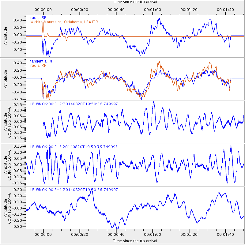
WMOK Wichita Mountains, Oklahoma, USA - Earthquake Result Viewer
*The percent match for this event was below the threshold and hence no stack was calculated.
| Earthquake location: |
Southeast Of Honshu, Japan |
| Earthquake latitude/longitude: |
33.2/138.1 |
| Earthquake time(UTC): |
2014/08/20 (232) 19:38:25 GMT |
| Earthquake Depth: |
308 km |
| Earthquake Magnitude: |
5.4 MW, 5.2 mb |
| Earthquake Catalog/Contributor: |
ISC/ISC |
|
| Network: |
US United States National Seismic Network |
| Station: |
WMOK Wichita Mountains, Oklahoma, USA |
| Lat/Lon: |
34.74 N/98.78 W |
| Elevation: |
486 m |
|
| Distance: |
93.9 deg |
| Az: |
43.747 deg |
| Baz: |
315.251 deg |
| Ray Param: |
$rayparam |
*The percent match for this event was below the threshold and hence was not used in the summary stack. |
|
| Radial Match: |
17.86905 % |
| Radial Bump: |
400 |
| Transverse Match: |
20.798986 % |
| Transverse Bump: |
400 |
| SOD ConfigId: |
3390531 |
| Insert Time: |
2019-04-13 12:06:15.460 +0000 |
| GWidth: |
2.5 |
| Max Bumps: |
400 |
| Tol: |
0.001 |
|
Signal To Noise
| Channel | StoN | STA | LTA |
| US:WMOK:00:BHZ:20140820T19:50:36.74999Z | 1.717084 | 9.388682E-8 | 5.4678054E-8 |
| US:WMOK:00:BH1:20140820T19:50:36.74999Z | 0.9123739 | 1.2230403E-7 | 1.3405034E-7 |
| US:WMOK:00:BH2:20140820T19:50:36.74999Z | 0.79056865 | 4.79592E-8 | 6.0664185E-8 |
| Arrivals |
| Ps | |
| PpPs | |
| PsPs/PpSs | |


