You are here: Home > Network List > TA - USArray Transportable Network (new EarthScope stations) Stations List
> Station 155A Kite, GA, USA > Earthquake Result Viewer
155A Kite, GA, USA - Earthquake Result Viewer
| Earthquake location: |
Northern Mid-Atlantic Ridge |
| Earthquake latitude/longitude: |
10.7/-42.6 |
| Earthquake time(UTC): |
2013/06/24 (175) 22:04:13 GMT |
| Earthquake Depth: |
10 km |
| Earthquake Magnitude: |
6.5 MW, 6.1 MB, 6.3 MS, 6.6 MW |
| Earthquake Catalog/Contributor: |
NEIC PDE/NEIC PDE-W |
|
| Network: |
TA USArray Transportable Network (new EarthScope stations) |
| Station: |
155A Kite, GA, USA |
| Lat/Lon: |
32.62 N/82.47 W |
| Elevation: |
93 m |
|
| Distance: |
42.6 deg |
| Az: |
307.011 deg |
| Baz: |
111.565 deg |
| Ray Param: |
0.07305253 |
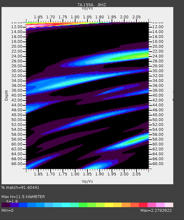
| Estimated Moho Depth: |
11.5 km |
| Estimated Crust Vp/Vs: |
1.60 |
| Assumed Crust Vp: |
6.565 km/s |
| Estimated Crust Vs: |
4.103 km/s |
| Estimated Crust Poisson's Ratio: |
0.18 |
|
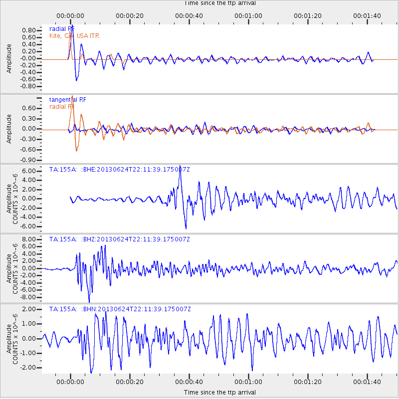
| Radial Match: |
91.60441 % |
| Radial Bump: |
400 |
| Transverse Match: |
84.19844 % |
| Transverse Bump: |
400 |
| SOD ConfigId: |
512894 |
| Insert Time: |
2013-09-15 09:35:16.192 +0000 |
| GWidth: |
2.5 |
| Max Bumps: |
400 |
| Tol: |
0.001 |
|
Signal To Noise
| Channel | StoN | STA | LTA |
| TA:155A: :BHZ:20130624T22:11:39.175007Z | 18.762152 | 2.1721978E-6 | 1.1577552E-7 |
| TA:155A: :BHN:20130624T22:11:39.175007Z | 2.0238032 | 4.229015E-7 | 2.0896375E-7 |
| TA:155A: :BHE:20130624T22:11:39.175007Z | 3.082309 | 9.2460925E-7 | 2.9997292E-7 |
| Arrivals |
| Ps | 1.1 SECOND |
| PpPs | 4.2 SECOND |
| PsPs/PpSs | 5.3 SECOND |


