You are here: Home > Network List > UW - Pacific Northwest Regional Seismic Network Stations List
> Station LEBA Lebam, WA, USA > Earthquake Result Viewer
LEBA Lebam, WA, USA - Earthquake Result Viewer
*The percent match for this event was below the threshold and hence no stack was calculated.
| Earthquake location: |
Rat Islands, Aleutian Islands |
| Earthquake latitude/longitude: |
50.4/177.0 |
| Earthquake time(UTC): |
2009/07/06 (187) 14:53:12 GMT |
| Earthquake Depth: |
22 km |
| Earthquake Magnitude: |
6.0 MB, 5.8 MS, 6.1 MW, 6.0 MW |
| Earthquake Catalog/Contributor: |
WHDF/NEIC |
|
| Network: |
UW Pacific Northwest Regional Seismic Network |
| Station: |
LEBA Lebam, WA, USA |
| Lat/Lon: |
46.55 N/123.56 W |
| Elevation: |
73 m |
|
| Distance: |
38.7 deg |
| Az: |
72.011 deg |
| Baz: |
298.208 deg |
| Ray Param: |
$rayparam |
*The percent match for this event was below the threshold and hence was not used in the summary stack. |
|
| Radial Match: |
74.84357 % |
| Radial Bump: |
400 |
| Transverse Match: |
65.40085 % |
| Transverse Bump: |
400 |
| SOD ConfigId: |
2648 |
| Insert Time: |
2010-02-27 04:42:01.953 +0000 |
| GWidth: |
2.5 |
| Max Bumps: |
400 |
| Tol: |
0.001 |
|
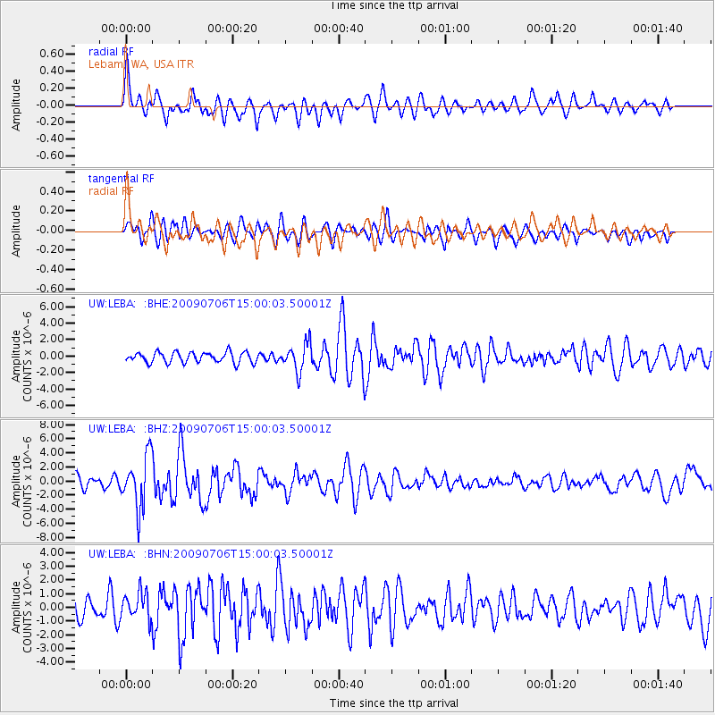
Signal To Noise
| Channel | StoN | STA | LTA |
| UW:LEBA: :BHZ:20090706T15:00:03.50001Z | 5.9701257 | 3.708106E-6 | 6.211102E-7 |
| UW:LEBA: :BHN:20090706T15:00:03.50001Z | 1.3519237 | 9.850238E-7 | 7.28609E-7 |
| UW:LEBA: :BHE:20090706T15:00:03.50001Z | 2.6722677 | 1.6820894E-6 | 6.294614E-7 |
| Arrivals |
| Ps | |
| PpPs | |
| PsPs/PpSs | |


