You are here: Home > Network List > TA - USArray Transportable Network (new EarthScope stations) Stations List
> Station 255A Hazlehurst, GA, USA > Earthquake Result Viewer
255A Hazlehurst, GA, USA - Earthquake Result Viewer
| Earthquake location: |
Northern Mid-Atlantic Ridge |
| Earthquake latitude/longitude: |
10.7/-42.6 |
| Earthquake time(UTC): |
2013/06/24 (175) 22:04:13 GMT |
| Earthquake Depth: |
10 km |
| Earthquake Magnitude: |
6.5 MW, 6.1 MB, 6.3 MS, 6.6 MW |
| Earthquake Catalog/Contributor: |
NEIC PDE/NEIC PDE-W |
|
| Network: |
TA USArray Transportable Network (new EarthScope stations) |
| Station: |
255A Hazlehurst, GA, USA |
| Lat/Lon: |
31.93 N/82.48 W |
| Elevation: |
45 m |
|
| Distance: |
42.4 deg |
| Az: |
306.05 deg |
| Baz: |
110.852 deg |
| Ray Param: |
0.07319361 |
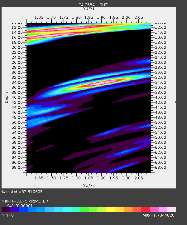
| Estimated Moho Depth: |
33.75 km |
| Estimated Crust Vp/Vs: |
1.91 |
| Assumed Crust Vp: |
6.565 km/s |
| Estimated Crust Vs: |
3.437 km/s |
| Estimated Crust Poisson's Ratio: |
0.31 |
|
| Radial Match: |
87.510605 % |
| Radial Bump: |
400 |
| Transverse Match: |
72.41684 % |
| Transverse Bump: |
400 |
| SOD ConfigId: |
512894 |
| Insert Time: |
2013-09-15 09:35:48.334 +0000 |
| GWidth: |
2.5 |
| Max Bumps: |
400 |
| Tol: |
0.001 |
|
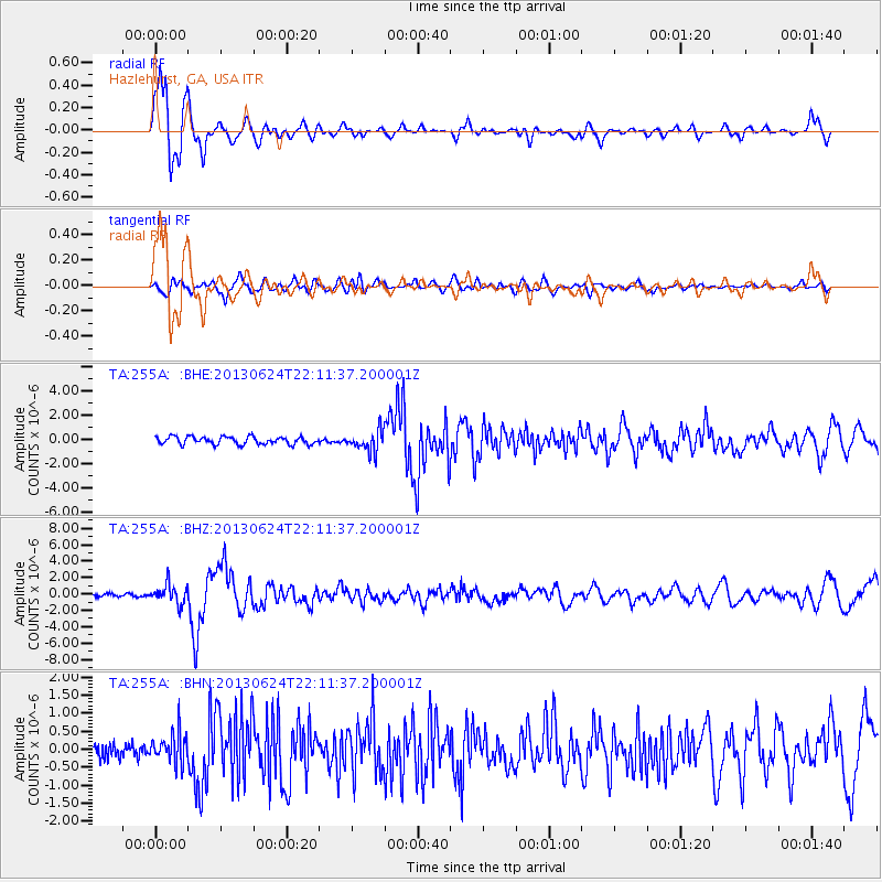
Signal To Noise
| Channel | StoN | STA | LTA |
| TA:255A: :BHZ:20130624T22:11:37.200001Z | 6.4928274 | 1.1608786E-6 | 1.78794E-7 |
| TA:255A: :BHN:20130624T22:11:37.200001Z | 1.6270574 | 4.2487324E-7 | 2.6112983E-7 |
| TA:255A: :BHE:20130624T22:11:37.200001Z | 2.703132 | 8.4376444E-7 | 3.1214327E-7 |
| Arrivals |
| Ps | 5.0 SECOND |
| PpPs | 14 SECOND |
| PsPs/PpSs | 19 SECOND |


