You are here: Home > Network List > UW - Pacific Northwest Regional Seismic Network Stations List
> Station LEBA Lebam, WA, USA > Earthquake Result Viewer
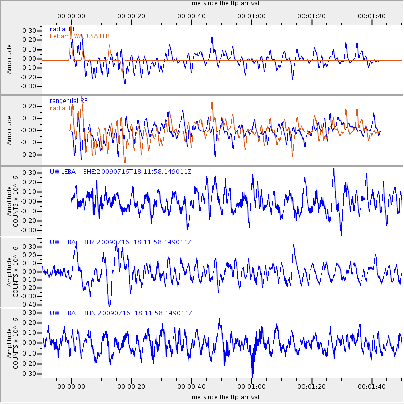
LEBA Lebam, WA, USA - Earthquake Result Viewer
*The percent match for this event was below the threshold and hence no stack was calculated.
| Earthquake location: |
Vanuatu Islands |
| Earthquake latitude/longitude: |
-17.5/167.7 |
| Earthquake time(UTC): |
2009/07/16 (197) 17:59:36 GMT |
| Earthquake Depth: |
10 km |
| Earthquake Magnitude: |
5.8 MW, 5.4 MS, 5.4 MB, 5.8 MW |
| Earthquake Catalog/Contributor: |
WHDF/NEIC |
|
| Network: |
UW Pacific Northwest Regional Seismic Network |
| Station: |
LEBA Lebam, WA, USA |
| Lat/Lon: |
46.55 N/123.56 W |
| Elevation: |
73 m |
|
| Distance: |
88.7 deg |
| Az: |
40.037 deg |
| Baz: |
242.78 deg |
| Ray Param: |
$rayparam |
*The percent match for this event was below the threshold and hence was not used in the summary stack. |
|
| Radial Match: |
52.063374 % |
| Radial Bump: |
400 |
| Transverse Match: |
54.927036 % |
| Transverse Bump: |
400 |
| SOD ConfigId: |
2648 |
| Insert Time: |
2010-02-27 04:42:08.240 +0000 |
| GWidth: |
2.5 |
| Max Bumps: |
400 |
| Tol: |
0.001 |
|
Signal To Noise
| Channel | StoN | STA | LTA |
| UW:LEBA: :BHZ:20090716T18:11:58.149011Z | 3.1115303 | 1.6597039E-7 | 5.334044E-8 |
| UW:LEBA: :BHN:20090716T18:11:58.149011Z | 1.4211925 | 7.2678056E-8 | 5.1138784E-8 |
| UW:LEBA: :BHE:20090716T18:11:58.149011Z | 1.1141888 | 7.9370906E-8 | 7.12365E-8 |
| Arrivals |
| Ps | |
| PpPs | |
| PsPs/PpSs | |


