You are here: Home > Network List > TA - USArray Transportable Network (new EarthScope stations) Stations List
> Station 456A Hilliard, FL, USA > Earthquake Result Viewer
456A Hilliard, FL, USA - Earthquake Result Viewer
| Earthquake location: |
Northern Mid-Atlantic Ridge |
| Earthquake latitude/longitude: |
10.7/-42.6 |
| Earthquake time(UTC): |
2013/06/24 (175) 22:04:13 GMT |
| Earthquake Depth: |
10 km |
| Earthquake Magnitude: |
6.5 MW, 6.1 MB, 6.3 MS, 6.6 MW |
| Earthquake Catalog/Contributor: |
NEIC PDE/NEIC PDE-W |
|
| Network: |
TA USArray Transportable Network (new EarthScope stations) |
| Station: |
456A Hilliard, FL, USA |
| Lat/Lon: |
30.72 N/82.02 W |
| Elevation: |
26 m |
|
| Distance: |
41.6 deg |
| Az: |
304.575 deg |
| Baz: |
109.991 deg |
| Ray Param: |
0.07367538 |
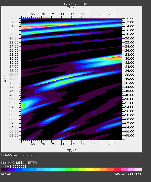
| Estimated Moho Depth: |
14.5 km |
| Estimated Crust Vp/Vs: |
1.60 |
| Assumed Crust Vp: |
6.565 km/s |
| Estimated Crust Vs: |
4.096 km/s |
| Estimated Crust Poisson's Ratio: |
0.18 |
|
| Radial Match: |
88.987625 % |
| Radial Bump: |
400 |
| Transverse Match: |
60.93322 % |
| Transverse Bump: |
400 |
| SOD ConfigId: |
512894 |
| Insert Time: |
2013-09-15 09:36:41.192 +0000 |
| GWidth: |
2.5 |
| Max Bumps: |
400 |
| Tol: |
0.001 |
|
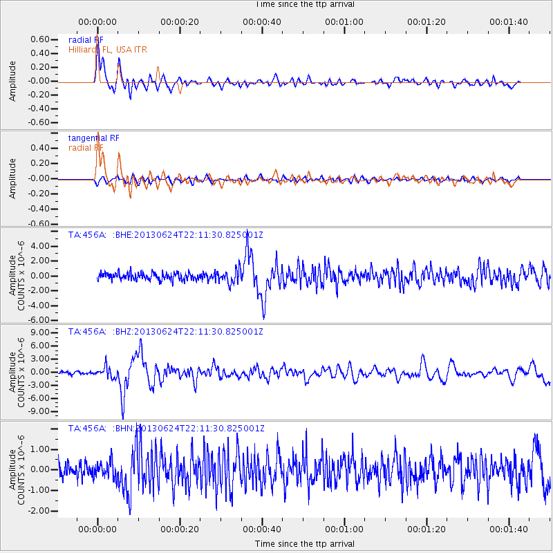
Signal To Noise
| Channel | StoN | STA | LTA |
| TA:456A: :BHZ:20130624T22:11:30.825001Z | 4.4377556 | 1.2394952E-6 | 2.7930676E-7 |
| TA:456A: :BHN:20130624T22:11:30.825001Z | 0.9759585 | 3.9116028E-7 | 4.00796E-7 |
| TA:456A: :BHE:20130624T22:11:30.825001Z | 2.0561125 | 9.2362575E-7 | 4.4920975E-7 |
| Arrivals |
| Ps | 1.4 SECOND |
| PpPs | 5.3 SECOND |
| PsPs/PpSs | 6.7 SECOND |


