You are here: Home > Network List > TA - USArray Transportable Network (new EarthScope stations) Stations List
> Station 859A Kempfer Cattle CO., St. Cloud, FL, USA > Earthquake Result Viewer
859A Kempfer Cattle CO., St. Cloud, FL, USA - Earthquake Result Viewer
| Earthquake location: |
Northern Mid-Atlantic Ridge |
| Earthquake latitude/longitude: |
10.7/-42.6 |
| Earthquake time(UTC): |
2013/06/24 (175) 22:04:13 GMT |
| Earthquake Depth: |
10 km |
| Earthquake Magnitude: |
6.5 MW, 6.1 MB, 6.3 MS, 6.6 MW |
| Earthquake Catalog/Contributor: |
NEIC PDE/NEIC PDE-W |
|
| Network: |
TA USArray Transportable Network (new EarthScope stations) |
| Station: |
859A Kempfer Cattle CO., St. Cloud, FL, USA |
| Lat/Lon: |
28.06 N/80.90 W |
| Elevation: |
13 m |
|
| Distance: |
39.8 deg |
| Az: |
301.215 deg |
| Baz: |
107.992 deg |
| Ray Param: |
0.07475443 |
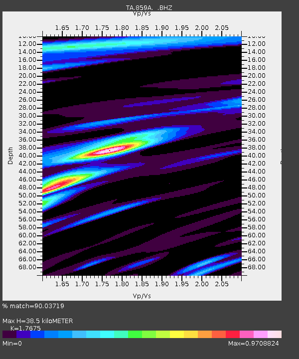
| Estimated Moho Depth: |
38.5 km |
| Estimated Crust Vp/Vs: |
1.77 |
| Assumed Crust Vp: |
6.134 km/s |
| Estimated Crust Vs: |
3.47 km/s |
| Estimated Crust Poisson's Ratio: |
0.26 |
|
| Radial Match: |
90.03719 % |
| Radial Bump: |
400 |
| Transverse Match: |
67.848175 % |
| Transverse Bump: |
400 |
| SOD ConfigId: |
512894 |
| Insert Time: |
2013-09-15 09:37:25.172 +0000 |
| GWidth: |
2.5 |
| Max Bumps: |
400 |
| Tol: |
0.001 |
|
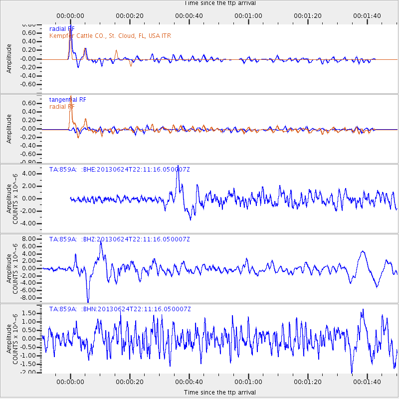
Signal To Noise
| Channel | StoN | STA | LTA |
| TA:859A: :BHZ:20130624T22:11:16.050007Z | 4.9561987 | 1.2375779E-6 | 2.4970302E-7 |
| TA:859A: :BHN:20130624T22:11:16.050007Z | 1.1085664 | 4.029288E-7 | 3.6346836E-7 |
| TA:859A: :BHE:20130624T22:11:16.050007Z | 2.450241 | 7.0208733E-7 | 2.8653807E-7 |
| Arrivals |
| Ps | 5.1 SECOND |
| PpPs | 16 SECOND |
| PsPs/PpSs | 21 SECOND |


