You are here: Home > Network List > TA - USArray Transportable Network (new EarthScope stations) Stations List
> Station 958A Wauchula, FL, USA > Earthquake Result Viewer
958A Wauchula, FL, USA - Earthquake Result Viewer
| Earthquake location: |
Northern Mid-Atlantic Ridge |
| Earthquake latitude/longitude: |
10.7/-42.6 |
| Earthquake time(UTC): |
2013/06/24 (175) 22:04:13 GMT |
| Earthquake Depth: |
10 km |
| Earthquake Magnitude: |
6.5 MW, 6.1 MB, 6.3 MS, 6.6 MW |
| Earthquake Catalog/Contributor: |
NEIC PDE/NEIC PDE-W |
|
| Network: |
TA USArray Transportable Network (new EarthScope stations) |
| Station: |
958A Wauchula, FL, USA |
| Lat/Lon: |
27.59 N/81.75 W |
| Elevation: |
30 m |
|
| Distance: |
40.4 deg |
| Az: |
300.165 deg |
| Baz: |
106.792 deg |
| Ray Param: |
0.074416116 |
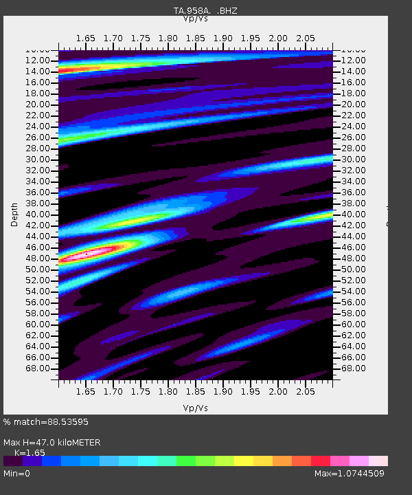
| Estimated Moho Depth: |
47.0 km |
| Estimated Crust Vp/Vs: |
1.65 |
| Assumed Crust Vp: |
6.347 km/s |
| Estimated Crust Vs: |
3.847 km/s |
| Estimated Crust Poisson's Ratio: |
0.21 |
|
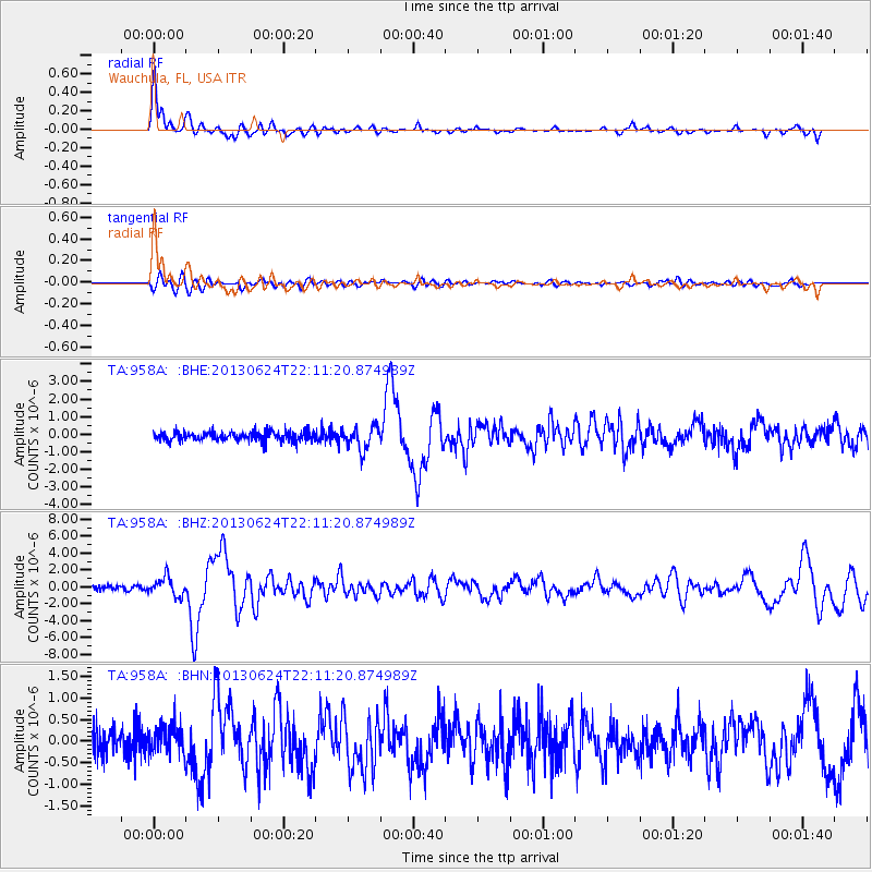
| Radial Match: |
88.53595 % |
| Radial Bump: |
398 |
| Transverse Match: |
69.544846 % |
| Transverse Bump: |
400 |
| SOD ConfigId: |
512894 |
| Insert Time: |
2013-09-15 09:37:28.369 +0000 |
| GWidth: |
2.5 |
| Max Bumps: |
400 |
| Tol: |
0.001 |
|
Signal To Noise
| Channel | StoN | STA | LTA |
| TA:958A: :BHZ:20130624T22:11:20.874989Z | 3.9778125 | 1.0894288E-6 | 2.7387637E-7 |
| TA:958A: :BHN:20130624T22:11:20.874989Z | 1.0912863 | 3.292552E-7 | 3.0171293E-7 |
| TA:958A: :BHE:20130624T22:11:20.874989Z | 2.4297113 | 6.5308353E-7 | 2.687906E-7 |
| Arrivals |
| Ps | 5.2 SECOND |
| PpPs | 18 SECOND |
| PsPs/PpSs | 23 SECOND |


