You are here: Home > Network List > TA - USArray Transportable Network (new EarthScope stations) Stations List
> Station C40A Isle Royale National Park, MI, USA > Earthquake Result Viewer
C40A Isle Royale National Park, MI, USA - Earthquake Result Viewer
| Earthquake location: |
Northern Mid-Atlantic Ridge |
| Earthquake latitude/longitude: |
10.7/-42.6 |
| Earthquake time(UTC): |
2013/06/24 (175) 22:04:13 GMT |
| Earthquake Depth: |
10 km |
| Earthquake Magnitude: |
6.5 MW, 6.1 MB, 6.3 MS, 6.6 MW |
| Earthquake Catalog/Contributor: |
NEIC PDE/NEIC PDE-W |
|
| Network: |
TA USArray Transportable Network (new EarthScope stations) |
| Station: |
C40A Isle Royale National Park, MI, USA |
| Lat/Lon: |
47.92 N/89.15 W |
| Elevation: |
216 m |
|
| Distance: |
53.8 deg |
| Az: |
322.731 deg |
| Baz: |
117.782 deg |
| Ray Param: |
0.0658823 |
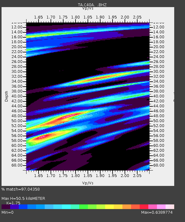
| Estimated Moho Depth: |
50.5 km |
| Estimated Crust Vp/Vs: |
1.75 |
| Assumed Crust Vp: |
6.467 km/s |
| Estimated Crust Vs: |
3.695 km/s |
| Estimated Crust Poisson's Ratio: |
0.26 |
|
| Radial Match: |
97.04358 % |
| Radial Bump: |
335 |
| Transverse Match: |
90.3259 % |
| Transverse Bump: |
400 |
| SOD ConfigId: |
512894 |
| Insert Time: |
2013-09-15 09:37:45.991 +0000 |
| GWidth: |
2.5 |
| Max Bumps: |
400 |
| Tol: |
0.001 |
|

Signal To Noise
| Channel | StoN | STA | LTA |
| TA:C40A: :BHZ:20130624T22:13:04.87502Z | 14.39286 | 1.6521489E-6 | 1.1478947E-7 |
| TA:C40A: :BHN:20130624T22:13:04.87502Z | 6.862736 | 3.9882894E-7 | 5.8115152E-8 |
| TA:C40A: :BHE:20130624T22:13:04.87502Z | 8.832897 | 6.234768E-7 | 7.058577E-8 |
| Arrivals |
| Ps | 6.2 SECOND |
| PpPs | 20 SECOND |
| PsPs/PpSs | 27 SECOND |


