You are here: Home > Network List > TA - USArray Transportable Network (new EarthScope stations) Stations List
> Station I45A Fountain, MI, USA > Earthquake Result Viewer
I45A Fountain, MI, USA - Earthquake Result Viewer
| Earthquake location: |
Northern Mid-Atlantic Ridge |
| Earthquake latitude/longitude: |
10.7/-42.6 |
| Earthquake time(UTC): |
2013/06/24 (175) 22:04:13 GMT |
| Earthquake Depth: |
10 km |
| Earthquake Magnitude: |
6.5 MW, 6.1 MB, 6.3 MS, 6.6 MW |
| Earthquake Catalog/Contributor: |
NEIC PDE/NEIC PDE-W |
|
| Network: |
TA USArray Transportable Network (new EarthScope stations) |
| Station: |
I45A Fountain, MI, USA |
| Lat/Lon: |
44.04 N/86.23 W |
| Elevation: |
215 m |
|
| Distance: |
50.2 deg |
| Az: |
319.584 deg |
| Baz: |
117.933 deg |
| Ray Param: |
0.06824741 |
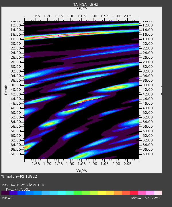
| Estimated Moho Depth: |
16.25 km |
| Estimated Crust Vp/Vs: |
1.75 |
| Assumed Crust Vp: |
6.53 km/s |
| Estimated Crust Vs: |
3.737 km/s |
| Estimated Crust Poisson's Ratio: |
0.26 |
|
| Radial Match: |
92.13822 % |
| Radial Bump: |
400 |
| Transverse Match: |
69.77287 % |
| Transverse Bump: |
400 |
| SOD ConfigId: |
512894 |
| Insert Time: |
2013-09-15 09:40:39.391 +0000 |
| GWidth: |
2.5 |
| Max Bumps: |
400 |
| Tol: |
0.001 |
|
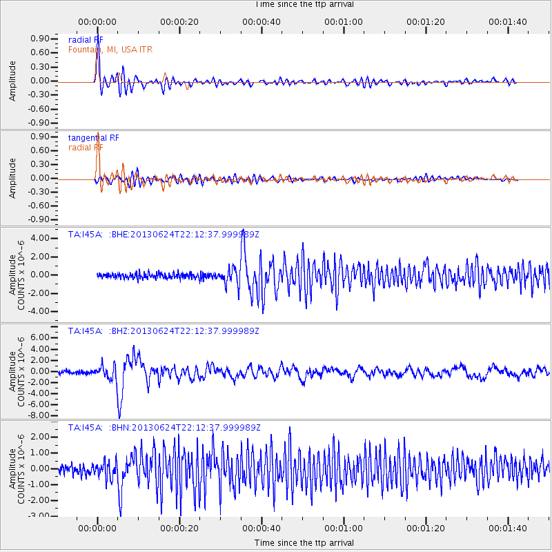
Signal To Noise
| Channel | StoN | STA | LTA |
| TA:I45A: :BHZ:20130624T22:12:37.999989Z | 5.480462 | 1.1937469E-6 | 2.1781865E-7 |
| TA:I45A: :BHN:20130624T22:12:37.999989Z | 2.1832712 | 4.9812485E-7 | 2.2815529E-7 |
| TA:I45A: :BHE:20130624T22:12:37.999989Z | 3.4157295 | 8.5653204E-7 | 2.5076108E-7 |
| Arrivals |
| Ps | 2.0 SECOND |
| PpPs | 6.4 SECOND |
| PsPs/PpSs | 8.4 SECOND |


