You are here: Home > Network List > TA - USArray Transportable Network (new EarthScope stations) Stations List
> Station K43A Burlington, WI, USA > Earthquake Result Viewer
K43A Burlington, WI, USA - Earthquake Result Viewer
| Earthquake location: |
Northern Mid-Atlantic Ridge |
| Earthquake latitude/longitude: |
10.7/-42.6 |
| Earthquake time(UTC): |
2013/06/24 (175) 22:04:13 GMT |
| Earthquake Depth: |
10 km |
| Earthquake Magnitude: |
6.5 MW, 6.1 MB, 6.3 MS, 6.6 MW |
| Earthquake Catalog/Contributor: |
NEIC PDE/NEIC PDE-W |
|
| Network: |
TA USArray Transportable Network (new EarthScope stations) |
| Station: |
K43A Burlington, WI, USA |
| Lat/Lon: |
42.70 N/88.33 W |
| Elevation: |
264 m |
|
| Distance: |
50.9 deg |
| Az: |
317.158 deg |
| Baz: |
114.956 deg |
| Ray Param: |
0.067733094 |
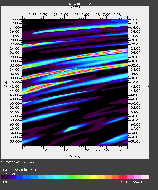
| Estimated Moho Depth: |
22.25 km |
| Estimated Crust Vp/Vs: |
1.60 |
| Assumed Crust Vp: |
6.571 km/s |
| Estimated Crust Vs: |
4.107 km/s |
| Estimated Crust Poisson's Ratio: |
0.18 |
|
| Radial Match: |
96.43946 % |
| Radial Bump: |
400 |
| Transverse Match: |
82.30003 % |
| Transverse Bump: |
400 |
| SOD ConfigId: |
512894 |
| Insert Time: |
2013-09-15 09:41:45.059 +0000 |
| GWidth: |
2.5 |
| Max Bumps: |
400 |
| Tol: |
0.001 |
|
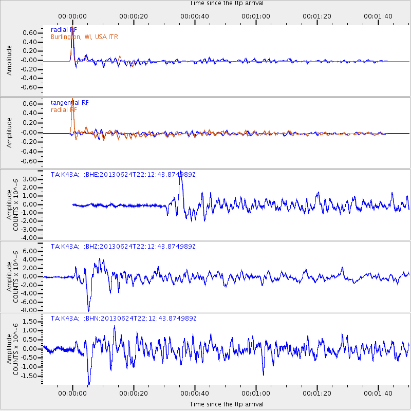
Signal To Noise
| Channel | StoN | STA | LTA |
| TA:K43A: :BHZ:20130624T22:12:43.874989Z | 15.23035 | 1.2749912E-6 | 8.371385E-8 |
| TA:K43A: :BHN:20130624T22:12:43.874989Z | 2.7958875 | 2.4300167E-7 | 8.6913964E-8 |
| TA:K43A: :BHE:20130624T22:12:43.874989Z | 6.9657607 | 5.8956897E-7 | 8.463813E-8 |
| Arrivals |
| Ps | 2.2 SECOND |
| PpPs | 8.2 SECOND |
| PsPs/PpSs | 10 SECOND |


